Two times a week, we go to a nice restaurant, have a little beverage, good food and companionship. She goes on Tuesdays, I go on Fridays.
We also sleep in separate beds. Hers is in California and mine is in Texas.
I take my wife everywhere...but she keeps finding her way back.
I asked my wife where she wanted to go for our anniversary. "Somewhere I haven't been in a long time!" she said. So I suggested the kitchen.
We always hold hands. If I let go, she shops.
She has an electric blender, electric toaster and electric bread maker. She said "There are too many gadgets and no place to sit down!" So I bought her an electric chair.
My wife told me the car wasn't running well because there was water in the carburetor. I asked where the car was; she told me "In the lake."
She got a mud pack and looked great for two days, then the mud fell off.
She ran after the garbage truck, yelling "Am I too late for the garbage?" ...The driver said "No, jump in!"
Remember: Marriage is the number one cause of divorce.
I married Miss Right. I just didn't know her first name was Always.
I haven't spoken to my wife in 18 months, I don't like to interrupt her.
The last fight was my fault though. My wife asked "What's on the TV?" I said "Dust!"
Wednesday, December 28, 2005
Thursday, December 22, 2005
MERRY CHRISTMAS!
May you have a safe and wonderful Christmas with your family and friends.
As for me I will pick a direction and go.
As for me I will pick a direction and go.
Tuesday, December 20, 2005
CARPE DIEM
Didn't sleep well last night and this morning. Wasn't anyone or anything keeping me awake. I get into thinking early in the morning.
I figured that my current condition with my back and sciatica is the result of becoming "soft." I have been accustomed to riding 25-30 miles per day. Riding 5 miles each way is not my idea of keeping an "edge."
A lot has transpired in my life these last few months. Some good and some bad. It is time for an attitude adjustment.
God grant me the serenity to accept the things I cannot change, courage to change the things I can and wisdom to know the difference.
Well, I know the things I cannot change and I know what I can change, but I don't need the wisdom to know the difference.
It is time I HAVE to make that difference. Today is the day of MY resurrection. I "cleansed" myself by riding 15.66 miles in 1:03:49 (ride day 132) on my Trek 6700 mountain bike.
That is something I haven't done since I rode 14.31 miles in 59:58 on April 27 (ride day 59).
Carpe diem.
I had to leave work early for a doctor appointment so I rode 5.36 miles in 21:07.
I rode for 21.02 miles. My first 20+ mile ride since September 8 the day after a tragic event.
Carpe diem.
Friday, December 09, 2005
THE DIFFERENCE BETWEEN LIBERALS, CONSERVATIVES AND ME
Scenario:
I am walking down a deserted street with my wife and my 2 children. Suddenly, Osama bin Laden and Saddam Hussein come around the corner and are running at us while screaming obscenities and wielding scimitars. In my hand is a Glock .40 and I am an expert shot. I have mere seconds before they reach us. What do I do?
If I were a Liberal…
Well, that's not enough information to answer the question!
Do they look poor or oppressed?
Have I ever done anything to them that is inspiring them to attack?
Could we run away?
What does my wife think?
What about the kids?
Could I possibly swing the gun like a club and knock the scimitars out of their hands?
What does the law say about this situation?
Is it possible they’d be happy with just killing me?
Do they definitely want to kill me or would they just be content to wound me?
If I were to grab their knees and hold on, could my family get away while they were stabbing me? This is all so confusing!
I need to debate this with some friends for a few days to try to come to a conclusion.
If I were a Conservative…
BANG!
But since I am not a Liberal or a Conservative…
BANG! BANG! BANG! BANG! BANG! BANG! BANG! BANG! BANG! click (sounds of clip being ejected and fresh clip installed)
Wife: “Sweetheart, he looks like he’s still moving. What do you kids think?”
Son: “Mom’s right, Dad, I saw them flinch.”
BANG! BANG! BANG! BANG! BANG! BANG! BANG! BANG! BANG!
Daughter: “Nice group, Daddy! Center mass! Can we go home now?”
That’s the way I am.
Disclaimer: This scenario does not reflect my political views. Humorous purposes only. Not responsible for content.
Thursday, December 08, 2005
SCIATICA
Sciatica...sounds like a name of a rock and roll band.
This morning while taking a shower I noticed my lower left leg was numb. No major cause for concern, but I am monitoring all the little aches, pains, and numbness and will see my doctor in about another week. It is time to take those soft mattress pads off the bed and sleep on a firm mattress. I have to stay active. Hiking may have to be put on hold, but maybe I can do short hikes with a lighter pack to ease back in.
I rode my bike again to work. Temperatures were not as cold as yesterday. I tried to stand up on my bike while pedaling to see how the leg would hold up. I couldn't.
I am experiencing discomfort as I sit at my desk. Relief comes when I force myself to walk around the confines of the office while looking busy at the same time.
A nice soaking in the Jacuzzi tonight is in order. Maybe a lap or two underwater in the pool may tweak me in the right way.
Refuse to yield.
Sunday, November 27, 2005
SUNDAY, NOVEMBER 27, 2005
The drive home. The following pictures are from my little "detours" home.
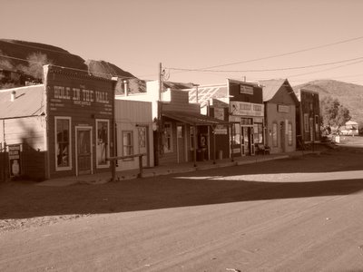
Downtown Randsburg. This town is 22 miles from Ridgecrest on the 395. It is a "living" ghost town.
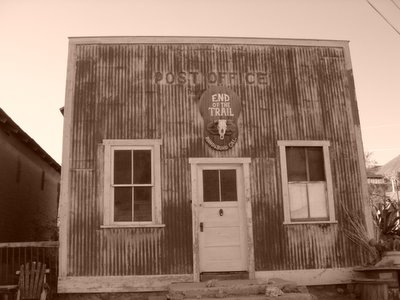
Randsburg Post Office.
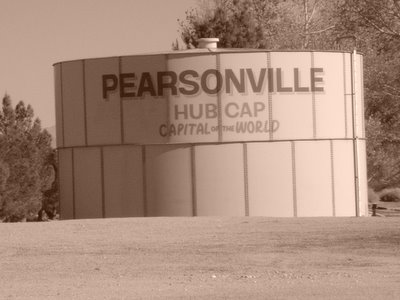
I did not see one single hubcap! Pearsonville is on the 395.
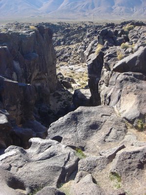
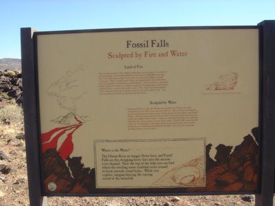
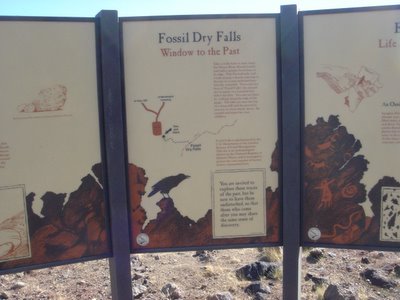
Fossil Falls. That's a 200-foot drop. The basalt has been worn smooth by the river that used to flow during "wetter" times.

Coso Junction. Wonder what this place was like back in its heyday?


Downtown Randsburg. This town is 22 miles from Ridgecrest on the 395. It is a "living" ghost town.

Randsburg Post Office.

I did not see one single hubcap! Pearsonville is on the 395.

Fossil Falls. That's a 200-foot drop. The basalt has been worn smooth by the river that used to flow during "wetter" times.


Coso Junction. Wonder what this place was like back in its heyday?
Saturday, November 26, 2005
SATURDAY, NOVEMBER 26, 2005
 Thought I would work on my tan after feasting on bacon, eggs, bread, and Minute Rice. Weather was quite warm. The radiant brilliance of the sun felt good agains my face and body.
I yelled out a rebel yell and probably scared the bejeezus out of everyone at the campsite. "It's okay folks! I just had to do it!"
My RV neighbors across from my campsite are good people. They are retired and are just living the life. We chat about life in general. I told them my story as to what has transpired in the course of almost 3 months. They have two nephews in the Army serving in Iraq. They are about to rotate out and come home for the holidays. They have two dogs with them. I offered both dogs a piece of bacon and my did I make new friends! I had two little shadows everywhere I went.
My whole day was spent cleaning up the site and putting away the non-essentials to get ready for my drive back to reality on Sunday. When all was done, I downed my traditional two cans of Fosters that I always have for my birthday (due to yesterday's adventure I had to postpone my celebration) as well as some Jack Daniel! Then it was a Mountain House meal of spaghetti with fresh minced garlic and parmesan cheese. I just love my Jetboil system!
The winds returned and not as strong, but this time I was in my REI Half Dome tent up against the rock. Through my tent, I could see the canopy of stars on this clear late November evening.
Where I lay my head is home...
Friday, November 25, 2005
FRIDAY, NOVEMBER 25, 2005
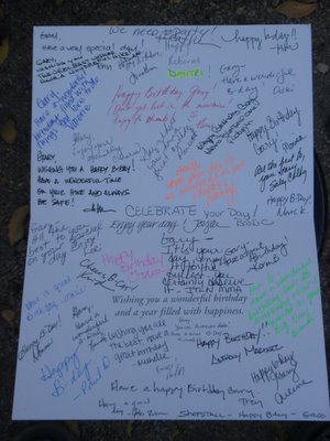
Today is my birthday #39! Yeah, right! Age ain't nothing but a number.
 This card is from my co-workers.
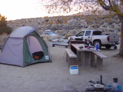 Lonepine Campground Site #1. Basecamp.
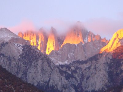 Sunrise. The clouds were an ominous sign.
What started out as a routine day turned out to be a hike of a lifetime. As you can plainly see from the photos, it was a nice sunny day except for the clouds at the top of Whitney. Yesterday, I got an updated weather report. A storm front was moving through. Meteorologists, BAH! What do they know!
I left my itinerary with my campground neighbors and my approximate time of return.
I struck out for the trail at around 7:00 a.m. and went up the old stock trail. I slowly paced myself past Lone Pine Lake, Outpost Camp, Mirror Lake, Trailside Meadows, Trail Camp.
At 11:45 a.m., I had reached the cables along the 99 switchbacks. All the trailrunning I have done since August did the trick. I experience no altitude sickness symptoms. No headaches and no breathing problems. I was making good time! Beyond the cables I could tell that this would be the end of the hike and it was time to head home. No sense of taking chances. Besides it was starting to snow.
I immediately went into descent mode. If I were to be snowed in, I was prepared. In my 30-pound Gregory Whitney pack, I packed my sleeping bag, bivy, Jetboil cooking system, 2 Mountain House dehydrated packages (Noodles & Chicken, Beef Stroganoff), 1 liter of water, Katadyn Hiker, Snickers, down jacket, balaclava, gloves, goggles, hunter orange cap. If I die, I die warm!
I literally ran off down the entire way doing the "recon shuffle." I got off the trail around 4:00 p.m. I did stop to take a look around to see the current conditions. It is snowing on my birthday! Yeah buddy!
My next worry was driving out of the portal area. I had snow cables, but my pickup does not come with four-wheel drive.
I got to Lone Pine campground in no time. No worries. As I made my way down along the road, I could see to the north that it was raining in the valley. As I made my way into camp, it started to rain.
Later that night, the winds had to be gusting 40 mph! It was blowing so hard that the tent was pressing against my face as if someone was sitting on the tent itself.
I took out my gear and placed it in the bed of my truck and strapped everything down. I moved my truck forward just to ensure that the tree would not get blown over. I doused the fire with and stirred it to make sure the embers were out. I place huge rocks inside the tent to keep it from blowing away.
I hunkered down in the cab of my truck for the rest of the night.
Happy Birthday, Gary!
Thursday, November 24, 2005
THANKSGIVING DAY, NOVEMBER 24, 2005
Thanksgiving Day. After a restful (and warm) sleep, I awoke to cook breakfast. It consisted of six sausage patties, three eggs, Minute Rice (had to have it), and V8 juice. There is nothing like cooking on an open fire. I tried to go over easy on the eggs, but wound up eating them scrambled. Oh well. I know my neighbors downwind from me were envious of me as I know the smell of sausage cooking made their olfactory senses go into overload.
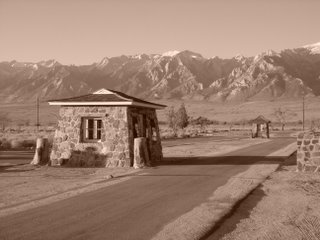
After feasting, I cleaned my dishes, straightened up the campsite and put everything into the bear lockers, I drove to the Manzanar War Relocation Center eight miles north of Lone Pine to pay my respects.
When I was growing up in Spanaway, Washington, my mother was friends with a "nisei" who was interned there. I wish I could turn back the hands of time and relive what this lady had to go through. I drove to the cemetery and said a prayer. I later drove around the camp to collect my thoughts.
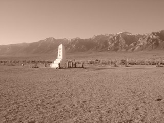
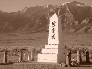
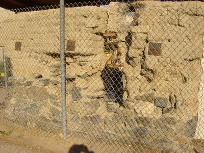
The Manzanar War Relocation Center was a Japanese-American internment camp during World War II. Manazanar was one of ten camps at which Japanese-Americans, both citizens and resident "aliens," were detained as a "precautionary measure" during World War II. Located at the foot of the imposing, Manzanar held 10,046 internees at its height. Many Japanese-Americans were forcibly relocated and interned. Most lost everything they owned. The camp was closed in November 1945. Many internees did not want to leave because most had nothing to return to. One hundred and thirty-five people died here, but only 15 were buried there (the rest were buried in hometown cemeteries). There is also a pet cemetery, too.
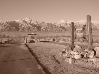
An obelisk shrine was built in the cemetery by a group of internees. There is an inscription in Japanese on the shrine that reads, "Monument to console the souls of the dead." The shrine currently is draped in strings of origami and has offerings of personal items left by survivors and visitors. The park service periodically itemizes and collects these items in order to gauge the changing feelings of visitors.
I left an origami crane I made myself and placed it at the base of the shrine. The winds will carry my crane to the site where my mother's friend once resided.
After feasting, I cleaned my dishes, straightened up the campsite and put everything into the bear lockers, I drove to the Manzanar War Relocation Center eight miles north of Lone Pine to pay my respects.
When I was growing up in Spanaway, Washington, my mother was friends with a "nisei" who was interned there. I wish I could turn back the hands of time and relive what this lady had to go through. I drove to the cemetery and said a prayer. I later drove around the camp to collect my thoughts.
The Manzanar War Relocation Center was a Japanese-American internment camp during World War II. Manazanar was one of ten camps at which Japanese-Americans, both citizens and resident "aliens," were detained as a "precautionary measure" during World War II. Located at the foot of the imposing, Manzanar held 10,046 internees at its height. Many Japanese-Americans were forcibly relocated and interned. Most lost everything they owned. The camp was closed in November 1945. Many internees did not want to leave because most had nothing to return to. One hundred and thirty-five people died here, but only 15 were buried there (the rest were buried in hometown cemeteries). There is also a pet cemetery, too.
An obelisk shrine was built in the cemetery by a group of internees. There is an inscription in Japanese on the shrine that reads, "Monument to console the souls of the dead." The shrine currently is draped in strings of origami and has offerings of personal items left by survivors and visitors. The park service periodically itemizes and collects these items in order to gauge the changing feelings of visitors.
I left an origami crane I made myself and placed it at the base of the shrine. The winds will carry my crane to the site where my mother's friend once resided.


Wednesday, November 23, 2005
WEDNESDAY, NOVEMBER 23, 2005
I started my trip at 5:10 a.m. I went up the 241-261-91-15-395 route. I made a little detour through the town of Ridgecrest and stopped at the Walmart and purchased the Steve Earle CD with the song, "Copperhead Road." I reached Lone Pine around 10:13 and was able to take a few pictures of the surrounding area. After my photo shoots, I proceeded up Whitney Portal Road to my destination at the Whitney Portal area. My first night at Whitney Portal was a very cold one. At this time of year, the portal area is shaded. The pine trees provided some protection from the elements, but I still froze my butt off. It is amazing how one can stare at a fire for hours to pass the time.
On March 16, 1872 at 2:30 a.m. Lone Pine, California was violently awakened by an earthquake. The magnitude of the quake was about the same as the "Big One" in San Francisco in 1906. It literally leveled the town of Lone Pine. Of the 80 buildings, built of mud and adobe, only 20 structures were left standing. Diaz Lake was formed by this quake. Twenty-six people lost their lives that day in the disaster. A mass grave, located just north of Lone Pine, on the upthrust block of the main fault that caused the quake commemorates the site.
 They still do this.
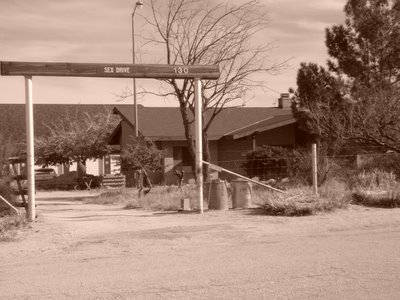 Yes, this is Lone Pine's version of Sex
Drive. A fellow ODCer directed me to this ranch. It belongs to her uncle.
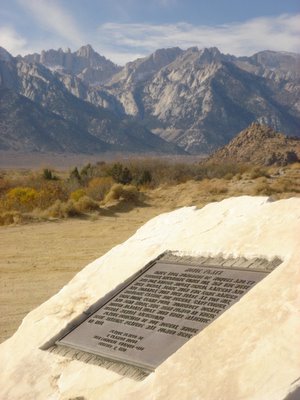 Movie Flats Road and Mt. Whitney. Many westerns were shot here. With its dramatic High Sierra backdrop, the Alabama Hills has long been a favorite location for television and movie companies. Since the early 1920's, movie stars such as Tom Mix, Hopalong Cassidy, Gene Autry and the Lone Ranger, have been shooting it out with outlaws. Classics such as "Gunga Din," "Springfield Rifle," and "How the West Was Won," were filmed on sites now known as "Movie Flats" and Movie Flat Rd. The area has been used for current movies such as Speilbergs "Tremors" shot in the 80s and most recently, in1992, "Joshua Tree." Some automobile commercials and advertisements are often filmed in this location.
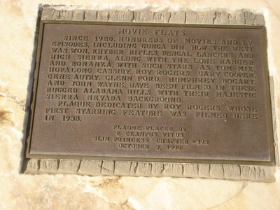 The plaque.
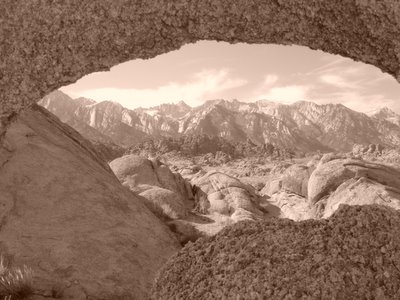 It took me forever to find this granite formation. There are two more. One requires a ladder to get the picture of a lifetime. Maybe next time. The Lone Pine Visitor Center provided me with the "secret map."
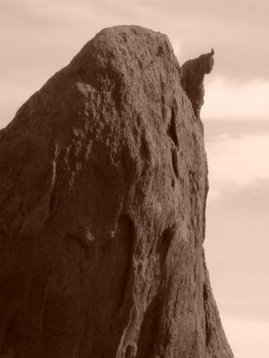
I call this "Thumbs Up Rock." This was nearby the rock formation photo I took above.
 On the way up.
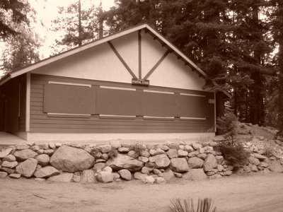 The Whitney Portal Store is closed for the winter season from November 1 until April 30.
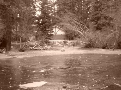 The frozen pond. People actually fish for brown trout here.

On March 16, 1872 at 2:30 a.m. Lone Pine, California was violently awakened by an earthquake. The magnitude of the quake was about the same as the "Big One" in San Francisco in 1906. It literally leveled the town of Lone Pine. Of the 80 buildings, built of mud and adobe, only 20 structures were left standing. Diaz Lake was formed by this quake. Twenty-six people lost their lives that day in the disaster. A mass grave, located just north of Lone Pine, on the upthrust block of the main fault that caused the quake commemorates the site.
 They still do this.
 Yes, this is Lone Pine's version of Sex
Drive. A fellow ODCer directed me to this ranch. It belongs to her uncle.
 Movie Flats Road and Mt. Whitney. Many westerns were shot here. With its dramatic High Sierra backdrop, the Alabama Hills has long been a favorite location for television and movie companies. Since the early 1920's, movie stars such as Tom Mix, Hopalong Cassidy, Gene Autry and the Lone Ranger, have been shooting it out with outlaws. Classics such as "Gunga Din," "Springfield Rifle," and "How the West Was Won," were filmed on sites now known as "Movie Flats" and Movie Flat Rd. The area has been used for current movies such as Speilbergs "Tremors" shot in the 80s and most recently, in1992, "Joshua Tree." Some automobile commercials and advertisements are often filmed in this location.
 The plaque.
 It took me forever to find this granite formation. There are two more. One requires a ladder to get the picture of a lifetime. Maybe next time. The Lone Pine Visitor Center provided me with the "secret map."
I call this "Thumbs Up Rock." This was nearby the rock formation photo I took above.
 On the way up.
 The Whitney Portal Store is closed for the winter season from November 1 until April 30.
 The frozen pond. People actually fish for brown trout here.
Tuesday, November 15, 2005
RECOMPRESSION
He has spent his life best who has enjoyed it most.
I have been invited to some of my co-workers' homes for Thanksgiving. They are trying to coax me out of going to Whitney alone. Bless their hearts. I thanked them for asking me into their homes, but my mind is set and I am going to do what I set out to do.
Alone, possibly yes. Lonely, no. Alone is a state of being, lonely is a state of mind. I am going to have fun!
I had planned to leave at 2:00 a.m., but I will leave at 4:00 a.m. instead. Instead of heading up the 405 to the 5 and to the 14, I will take the 91 to the I-15 to the 395 and northwards to the holy city of Lone Pine. I feel in my heart this may be the better way to go, but I won't know that until I am on the road jamming to the sounds of Metallica, Steve Earle ("Copperhead Road"), Ozzy, Nugent, Dio, REO Speedwagon. Sunrise will be around 6:30 and I hope to be in the middle of nowhere as it peeks above the eastern horizon.
I expect to be at "base camp" around 8:3o a.m. My first stop is the Sierra Cafe for a big, and I mean big, breakfast. I will keep my ears open for any bit of information. The ranger station is closed this time of year and the locals aren't exactly a good source of information. To them, Mt. Whitney is just another mountain. After gorging myself, I will head up to Whitney Portal to claim my spot. The early bird is going to get his "worm."
It doesn't matter if I am the only one at Whitney Portal or one of a few dozen camping up there on Thanksgiving Day. I hope to meet some interesting people. You never know who you might meet.
If my fellow campers are experiencing their first visit ever at Whitney Portal or have never been on the Mt. Whitney Trail, you can guarantee it I will provide them with as much information as I can. I like to share my Mt. Whitney experiences. I am a valuable resource. I am almost a docent in these here parts.
I will take the time to show them around some of the great trails in the area. Meysan Lakes trail. Whitney Portal National Recreation Trail. The Mt. Whitney Trail where I will show them the "dry" route (old stock trail) and the "wet" one (the current trail).
If trail conditions are favorable, I will take them to the John Muir Wilderness sign, Lone Pine Lake and Outpost Camp. I will show them the secret spring near Big Horn Park.
I will tell them about other places to visit while in the area like the town of Lone Pine (the film festival occurs the first half of every October), the Alabama Hills (where some of the greatest western movies were filmed), the Manzanar War Relocation Center (Japanese internment camp during WWII 8 miles north of Lone Pine), and the ancient Bristlecone Pine Forest (home to Methuselah, the oldest living thing on this planet at 4,767 years-old). There are other places too many to mention. They, too, have a rich history.
On the flip side, should I be the only soul on the mountainside, then I will make good use of my time. Come and go and wander whenever I want. I am bringing a lot of food. The my breakfasts I am bringing bacon, eggs, sausage, muffins. For my lunches and dinners, I will dine on various entrees by Mountain House, hot dogs, hamburgers, potato chips, chili. One thing is for certain, if there are any bears hibernating up there, they won't be as long as I am there. Yes, I will be bringing Minute Rice. Can't bring my small rice cooker. Can't find an extension cord long enough to reach Lone Pine. There are plenty of bear lockers in the area so my food will be safe. I just have to make sure I don't cook, eat and sleep in the same clothes. Wouldn't be prudent!
No portable CD player, portable radio, cellular phone (it will be turned off), musical instrument, newspaper. Just me, my digital camera, and the sights and sounds of the Sierra Nevada. I may bring a book or magazine, but I doubt I will ever open up the pages.
I am looking forward to this trip no matter what the circumstances are. Snow or no snow.
To all my fellow bloggers out there, if there are no more posts on this blog long after the Thanksgiving Day weekend, you can assume that I had died enjoying what I like to do most. Common sense will dictate my actions during my stay. I did not request permission to die on this trip. By God, if I had to drive 5 hours to get here I am going to get my time worth!
Accidents do happen. If something does happen, all is taken care of. My organs are to be donated so that others may live to enjoy life the way I have. My body is to be cremated and my ashes scattered at a pre-determined location. I do not want to be buried in a stainless steel box six feet under with a granite marker telling the world when I was born and when I died. No one is going to care in 20 years anyhow. The world is one big burial ground as it is. My ashes will make great fertilizer!
It is said that when people are born, their hands are clenched. When they leave this world, their hands are open. Upon entering life, they tend to grab everything. Upon leaving, everything they had possessed has slipped away.
The only marker I ask is that a bristlecone pine be planted so that others can marvel the beauty of my tree 4,000 years from now.
Move over, Methuselah!
Samuel Butler
I have been invited to some of my co-workers' homes for Thanksgiving. They are trying to coax me out of going to Whitney alone. Bless their hearts. I thanked them for asking me into their homes, but my mind is set and I am going to do what I set out to do.
Alone, possibly yes. Lonely, no. Alone is a state of being, lonely is a state of mind. I am going to have fun!
I had planned to leave at 2:00 a.m., but I will leave at 4:00 a.m. instead. Instead of heading up the 405 to the 5 and to the 14, I will take the 91 to the I-15 to the 395 and northwards to the holy city of Lone Pine. I feel in my heart this may be the better way to go, but I won't know that until I am on the road jamming to the sounds of Metallica, Steve Earle ("Copperhead Road"), Ozzy, Nugent, Dio, REO Speedwagon. Sunrise will be around 6:30 and I hope to be in the middle of nowhere as it peeks above the eastern horizon.
I expect to be at "base camp" around 8:3o a.m. My first stop is the Sierra Cafe for a big, and I mean big, breakfast. I will keep my ears open for any bit of information. The ranger station is closed this time of year and the locals aren't exactly a good source of information. To them, Mt. Whitney is just another mountain. After gorging myself, I will head up to Whitney Portal to claim my spot. The early bird is going to get his "worm."
It doesn't matter if I am the only one at Whitney Portal or one of a few dozen camping up there on Thanksgiving Day. I hope to meet some interesting people. You never know who you might meet.
If my fellow campers are experiencing their first visit ever at Whitney Portal or have never been on the Mt. Whitney Trail, you can guarantee it I will provide them with as much information as I can. I like to share my Mt. Whitney experiences. I am a valuable resource. I am almost a docent in these here parts.
I will take the time to show them around some of the great trails in the area. Meysan Lakes trail. Whitney Portal National Recreation Trail. The Mt. Whitney Trail where I will show them the "dry" route (old stock trail) and the "wet" one (the current trail).
If trail conditions are favorable, I will take them to the John Muir Wilderness sign, Lone Pine Lake and Outpost Camp. I will show them the secret spring near Big Horn Park.
I will tell them about other places to visit while in the area like the town of Lone Pine (the film festival occurs the first half of every October), the Alabama Hills (where some of the greatest western movies were filmed), the Manzanar War Relocation Center (Japanese internment camp during WWII 8 miles north of Lone Pine), and the ancient Bristlecone Pine Forest (home to Methuselah, the oldest living thing on this planet at 4,767 years-old). There are other places too many to mention. They, too, have a rich history.
On the flip side, should I be the only soul on the mountainside, then I will make good use of my time. Come and go and wander whenever I want. I am bringing a lot of food. The my breakfasts I am bringing bacon, eggs, sausage, muffins. For my lunches and dinners, I will dine on various entrees by Mountain House, hot dogs, hamburgers, potato chips, chili. One thing is for certain, if there are any bears hibernating up there, they won't be as long as I am there. Yes, I will be bringing Minute Rice. Can't bring my small rice cooker. Can't find an extension cord long enough to reach Lone Pine. There are plenty of bear lockers in the area so my food will be safe. I just have to make sure I don't cook, eat and sleep in the same clothes. Wouldn't be prudent!
No portable CD player, portable radio, cellular phone (it will be turned off), musical instrument, newspaper. Just me, my digital camera, and the sights and sounds of the Sierra Nevada. I may bring a book or magazine, but I doubt I will ever open up the pages.
I am looking forward to this trip no matter what the circumstances are. Snow or no snow.
To all my fellow bloggers out there, if there are no more posts on this blog long after the Thanksgiving Day weekend, you can assume that I had died enjoying what I like to do most. Common sense will dictate my actions during my stay. I did not request permission to die on this trip. By God, if I had to drive 5 hours to get here I am going to get my time worth!
Accidents do happen. If something does happen, all is taken care of. My organs are to be donated so that others may live to enjoy life the way I have. My body is to be cremated and my ashes scattered at a pre-determined location. I do not want to be buried in a stainless steel box six feet under with a granite marker telling the world when I was born and when I died. No one is going to care in 20 years anyhow. The world is one big burial ground as it is. My ashes will make great fertilizer!
It is said that when people are born, their hands are clenched. When they leave this world, their hands are open. Upon entering life, they tend to grab everything. Upon leaving, everything they had possessed has slipped away.
The only marker I ask is that a bristlecone pine be planted so that others can marvel the beauty of my tree 4,000 years from now.
Move over, Methuselah!
Wednesday, November 09, 2005
SOLO
Received word this morning that an interested ODClub hiker from the Bay Area will not be joining me for my trip to Mt. Whitney area during the Thanksgiving Day weekend. At least he told me in advance. So it is I who is the only one listed on the activity. I get to be my own leader and follower and sweeper. How about that!
Solo I go.
I wonder who I will meet at Whitney Portal? What will I see? What will the weather be like? That would be interesting. You never know who you might meet, or what you might see, or what you may experience. I may have the whole place to myself with the exception of possibly a bear, a marmot, a chipmunk, a squirrel, a mule deer, a Clark's jay letting me know I am in THEIR house and in THEIR yard!
At home last night while I was going through my my cold weather gear to prepare for my trip, I was trying to figure out what I wanted to do on my birthday that I have never done in my life. I came here last year but didn't stay for my birthday on Thanksgiving Day. This time I wanted to make it special to make up for last year. Then it hit me like a bolt out of the blue.
This is what I will do on Friday, November 25:
I will try to do what I always wanted to do but never got around to doing during my summer visits. If during my reconaissance hike on Wednesday I find the trails are clear of snow, I will run from Whitney Portal to Lone Pine Lake and back. That's a 5.6 mile roundtrip "run" starting from 8,365 feet above sea level to 9,960 feet. You can guarantee I will run a little further and top out at 10,000 feet before I make my descent.
I know someone out there has done this and it was a walk in the park for them. For me, it's a challenge. I remember a quote I once read: Never back away from a challenge if it is something you really want to do. Duck it, and it will nag you the rest of your life.
Time to put that "nag" to rest!
What I will do to have fun.
Sunday, October 30, 2005
BACK IN THE SADDLE

Taken at Castaway Park in Newport Beach overlooking Back Bay.
That's me kneeling on the right with my Team In Training jersey. The dog didn't have a bike or a helmet so it couldn't ride with us. It just wanted its picture taken. Camera hog dog.
I have started to ride my mountain bike on weekends which is something I haven't done since March 27. With all the hiking I do on the weekends, it's no wonder.
It is time for a change of pace. Cross-training. Call it what you will. Cycling, trailrunning, hiking. It all comes together.
So yesterday, on October 29, I rode with my friends on a leisurely ride from Irvine to Newport Back Bay along the San Diego River Trail. Nice day. Not a cloud in the sky. Had to make a slight detour near Back Bay since there was a dog show going on and the local authorities had closed the road from Newport Back Bay to San Joaquin Hills Road.
We went to the Baja Fresh restaurant in Oak Creek Village Food Court in Irvine at Alton and Jeffrey for a post-ride together and lunch. For one member of our group today's ride was her first physical activity since she completed her radiation therapy for breast cancer. Her name is Cynthia. She is the lady second from the right in the above picture. She had a pink "Race for the Cure" cap on while she was eating. I was going to ask her if she was a survivor because I knew all survivors who enter this race get the coveted pink t-shirt and hat as a testament to their will, strength and courage.
I gave her a hug. She deserved it. My heart felt good.
Sunday, October 16, 2005
FIRST SNOW

The clouds obscure what is beneath.
(Photo courtesy of Nunya)

Closer to the destination.
(Photo courtesy of Nunya)

We're here!
(Photo courtesy of Nunya)

The Sierra Club Gang. I am not a member.
(Photo courtesy of Nunya)

Prepping.
(Photo courtesy of Nunya)

Moi.
(Photo courtesy of Nunya)

Chitchatting.
(Photo courtesy of Nunya)

Move out!
(Photo courtesy of Nunya)

Two down, two to go.
(Photo courtesy of Nunya)

One of the many switchbacks.
(Photo courtesy of Nunya)

Up.
(Photo courtesy of Nunya)

Snow level.
(Photo courtesy of Nunya)

Still going...up.
(Photo courtesy of Nunya)
 Snow comes early on October 16, 2005 in the Angeles National Forest along the Baden-Powell Trail. It started snowing above the 7,000 foot level late in the night of October 15, 2005. The winds were between 20-30 mph. Rain at the lower elevations. Snow at the higher elevation. It was a good day for a hike.
 Bear tracks along the Baden-Powell trail. The size of the track is almost 6 inches across. That is my size 10-1/2 Montrail boot. Judging from the size of the print, this was one big bear! Maybe this print belongs to the Abominable Snowman who walks on his tippy-toes!
Monday, October 10, 2005
TRAGEDY ON THE 99 SWITCHBACKS ON THE MT. WHITNEY TRAIL

The following is an article from the San Francisco Chronicle about a hiking tragedy on the slopes of Mt. Whitney on October 3, 2005. Mt. Whitney is still dangerous if you overestimate your limits and underestimate the power of the mountain. My condolences to the Tom Family.
Shortly before he died on the icy and rocky slopes of Mount Whitney on Monday afternoon, Stephen Tom told his hiking partner that the conditions were too treacherous to reach the mountain's summit and he would descend back to the base camp.
"He said, 'I have nothing to prove,' " said Jim Kramer, recalling the words of Tom, a 45-year-old El Cerrito resident, after they had finished a section of the trail that ascends more than 1,700 feet up switchbacks from Trail Camp to Trail Crest.
But Kramer continued to Whitney's 14,497-foot summit, while Tom -- whom friends and family describe as a cautious and calculated risk taker -- and another hiker they had met on the mountain decided it would be safer to sit and slide down a snow chute used by some people during their descent.
The technique, called glissading, could cut an hours-long hike to Trail Camp to as little as 15 minutes and avoid the nearly 100 icy and treacherous switchbacks on the trail. They had watched a hiker glissade the chute earlier in the day, and Tom was an experienced skier and snowboarder.
But the early fall snow was shallow, and after sliding on their backsides for a few hundred feet from the 13,777-foot crest, the snow-covered top portion of the chute gave way to ice.
"It was mind-boggling to me how quickly he could pick up speed. He went from in control to out of control almost instantly," said Michael McEntee, 44, a Mountain View resident who was descending with Tom.
Tom had hiking poles that he tried to use as brakes. He turned on his stomach, facing up the mountain, and tried to slow himself with his feet. At the bottom of the chute, Tom was moving so fast -- at least 50 miles per hour, the accident investigator estimates -- that he could not stop. He hit a refrigerator-size boulder on the edge of the snow meadow and died from the impact.
"You're up so high your perspective is skewed," McEntee said. "I don't think either of us imagined it would be possible to slide across that flat part into rock."
McEntee climbed to a rocky area after he saw Tom lose control. He called for help, and other hikers on the trail guided him to safety. He was uninjured.
The next day, two other hikers glissaded down the chute and lost control, said Sgt. Randy Nixon of the Inyo County sheriff's department. One hiker broke a leg, and the other was knocked unconscious after hitting rocks; both were rescued by helicopter.
"(Glissading) is one of those things that experienced climbers probably won't do," said SP Parker, an internationally certified guide who is a partner in the Sierra Mountain Center, a guiding company in Bishop. Several years ago, Parker led a group on the trail and saw five people injured -- two seriously -- in one day from sliding down the chute.
"It's tempting because it looks so easy," Parker said. "But it's one of the most dangerous things in mountaineering."
Anyone attempting the technique, which can also be done while crouching or standing, should be experienced and have equipment, such as a helmet and an ice ax for braking, Parker said. Tom, who had glissaded once before, 20 years ago, had no equipment besides the poles, his family said.
In the past 12 years, three people have died while glissading on the chute, and about a dozen have suffered injuries requiring helicopter evacuation, Nixon said. He said he does not know how many people have suffered minor or moderate injuries.
Many people have been known to perform the maneuver successfully. Kramer, who descended the chute later in the day, is one of them. He avoided injury by going slowly down the mountain -- it took him an hour -- though he sped up at the bottom and caught air off a boulder. To his horror, he said, he landed near Tom's body, which was not recovered until Tuesday.
In the summer, no special equipment is required to reach the peak of Mount Whitney, the highest point in the lower 48 states. Some people make the nearly 22-mile round trip from Whitney Portal to the summit in one day if conditions are optimal, but others prefer to backpack to one of the camps along the trail such as Outpost Camp, where Tom's group stayed, about 7 miles from the summit.
While weather conditions were good when the two started out Monday, two storms in the past few weeks had made for a slower and more treacherous ascent. The hike from Outpost Camp to Trail Crest had taken about five hours before Tom and McEntee decided to turn back.
At Outpost Camp the night before, Tom had been in typical form -- generous and caring, according to family members -- sharing his tent with a day hiker who was unable to descend the mountain by nightfall. The hiker's girlfriend, who had snow blindness from the trek, was invited to share the tent of some women at the camp.
"Stephen immediately asked if they wanted something to eat or drink, and he gave them miso soup and hot cider," said Mark Kramer, a close friend of Tom and cousin of Jim Kramer who initiated the trip but elected to stay at the base camp that day with a fourth member of the group.
"He was one of the most generous, thoughtful people you could meet. He was a solid, solid friend and a good person," said Mark Kramer, who met Tom when they went to college at UC San Diego 25 years ago.
Tom grew up in Oakland and Danville, graduating from Bishop O'Dowd High School in Oakland. He later graduated from UC San Diego and received his master's degree from the Thunderbird Garvin School of International Management in Glendale, Ariz. He was employed in real estate management for General Electric in Concord. He enjoyed outdoor adventures and was excited to climb the mountain, Mark Kramer said.
"Stephen was doing three of the things that he loved most -- spending time with friends, challenging himself in physical endurance and roughing it in the wild -- when he died," said his brother, Daryl Tom of Danville.
In addition to his brother, he is survived by his parents, Leonard and Katie Tom of Danville; and brothers David Tom and Stuart Tom.
A memorial service for Tom will be held today at 6 p.m. at Wilson & Kratzer Chapel of San Ramon Valley, 825 Hartz Way in Danville. A funeral will be held at 10 a.m. Monday at St. John the Baptist Catholic Church at 11150 San Pablo Ave., El Cerrito.
The family asks that donations in Tom's memory be made to the Red Cross Disaster Relief Fund.
Monday, September 12, 2005
SELFLESS ACT (FOLLOW-UP)
This is a follow-up to the post about my friend's "friend."
Turns out that her "friend" who fell ill was her daughter, Ashley.
What a mom!
Turns out that her "friend" who fell ill was her daughter, Ashley.
What a mom!
Thursday, September 08, 2005
SELFLESS ACT
I called my friend, Kandace, and left a message on her voicemail to see how she did on Mt. Whitney.
She returned my call about 30 minutes later. She did not reach the summit. She had to turn around just short of Trail Camp which is about 6 miles (12,000 feet elevation) into the hike to the summit over narrow trails and switchbacks.
One of her hiking friends was vomiting severely and was unable to proceed. Nerves? Altitude? Something she ate? Answers unknown. Situation critical. Her friend needed to get off that trail immediately. Kandy thought it would be best to stay with her friend and return to Whitney Portal. Both made it back safely through the 6 mile ordeal to the trailhead and returned to Lone Pine. I can only imagine that it was probably the longest 12 miles both had to endure.
Kandy, I know you read my blog. And I want you to know and everyone who reads this blog to know what you did was a class act far above and beyond as a friend comforting a friend in a time of dire need. You adhered to the golden rule in hiking by never leaving anyone alone on a trail. Your friend was probably the luckiest person in the world today to have a hiking friend like you by her side on the trail every step of the way. I know how much this hike meant to you and you trained hard since March when you found out you got your Whitney hiking permit. But your heart should feel good. You did the right thing.
I hope to be able to secure a permit through next year's Whitney lottery in February. If I do, there will be a spot on my team for you with your name on it, Kandy. You earned it!
Selfless acts has its rewards in my book.
Thursday, August 25, 2005
RITER
I have binn told I is a "very well" riter and that I shude I have my "Mike Echo" storey publisht.
Truth iz I am AINT NOT a good riter. I just start from the hart or whatever comes too mind and lett it floe.
I must cunfess my vokabulary is very limitd, so I won't has you scurrying for the Rojay's Thawsawrus each and every time I rite in my blog.
Their, nuff sedd.
Truth iz I am AINT NOT a good riter. I just start from the hart or whatever comes too mind and lett it floe.
I must cunfess my vokabulary is very limitd, so I won't has you scurrying for the Rojay's Thawsawrus each and every time I rite in my blog.
Their, nuff sedd.
Saturday, August 20, 2005
MT. SAN ANTONIO ("BALDY") (click here for more info)

Dead tree reference along on the San Antonio Road.

The Baldy Bowl Trail starts just past the little pine tree along the road on the right.

The Baldy Bowl Trail. There is a register about 50 yards into the trail to log in the date of your ascent and whatever comments you wish to make. Unfortunately, there was no pen or paper. By the way, notice there is no trail sign. Keep scrolling down for the new sign!

The Christmas Tree at the Ski Hut. This tree is adorned with Christmas ornaments. No one knows how it all got started. The ski hut is to the left in the picture.

The summit tree. Once you see this you are near the top of 10,064. You can see some of the trail to the right of the picture.

Summit time. Thank goodness for digital cameras!

Bagged again.

Kicking back at the summit and taking in the panoramic views. Santiago Peak (Saddleback) (5,687 feet) way in the background. It was very windy at the top. My estimate is that the winds were 20-25 miles an hour. It was an exceptionally clear late August day. I couldn't see the ocean due to the marine layer, but I was able to see the Sierra Nevada, Mt. San Gorgonio (11,501), San Jacinto (10,834), Edwards AFB. I did not don my cold weather gear. I decided it was best to take advantage of the rock windbreaks and sun dry myself.

Laura Bieser, Outdoors Club hiker. She joined me at the summit half an hour after I did. This is picture was taken along Devil's Backbone Trail on the descent. Mt. Harwood (9,552) is to Laura's left.

Look back up towards the summit. Going up to the summit from Manker Flats via San Antonio Road to Baldy Notch and then along Devil's Backbone is about 6.8 miles. There are steep sections along this route from Baldy Notch to the beginning of Devil's Backbone. Then as you make your final push to the summit, the last one-half mile or so is a very challenging climb. The Baldy Bowl Trail is 4.2 miles (add .9 miles from Manker Flats to the trailhead) and is somewhat of a challengin climb in itself with narrow trails with precipitous drops as well as large rocks and scree.

Laura at the "new" trailhead sign that wasn't there in the morning. So many hikers who are unfamiliar with the trail miss this trailhead. If you blink, you will miss it. The trail is well "camouflaged." This sign will help hikers who are new on the trails and are looking for adventure.
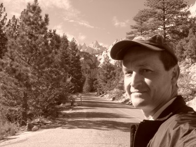
 Me.
Me.My first "solo" hike of Baldy via the Baldy Bowl Trail. It wasn't planned to be this way. I do not like hiking solo, but since this trail is well-travelled with hikers and summit runners I didn't see any harm of heading off on my own. I waited for another Outdoors Club member, Laura Bieser, who wanted to hike with me. The leader of this ODC hike wanted to start at 10:00 a.m., but I felt this too late in the day to start. Laura emailed me and said she would like to join me.
I arrived at Manker Flats just short of 7:00 a.m. I parked my truck and looked around to see if I could spot Laura's Range Rover. I did not see it anywhere. I waited and waited. Figuring that she may have changed her mind about the hike, I hit the trail at 7:20 a.m.
I took some photographs to use as reference points for other hikers who may read this blog and may want to hike the BBT in the future. As I turned up onto the trail, I heard my name being called. It was Kandace Dunbar, a fellow hiker and soon-to-be Whitney hiker (09/08/05), who was with her hiking party. She yells, "See you at the summit!" I reply, "Maybe."
I stopped at the registry to sign in with my name and date and to make comments. To my dismay, there was a spiral notebook with no paper and there was no pen to be found. Oh well. I got a hill to climb.
Portions of the BBT are a bit difficult, but with trekking poles in hand, the ascent is not that foreboding.
I reached the Ski Hut at around 8:38 a.m. I stopped to take a picture of the Christmas Tree with its holiday ornaments. The tree is immediately off trail as you depart the main trail and head towards the hut.
After about a minute of rest and photo opportunities, I proceeded up the trail. At the rate I was going, I figured I was going to make great time. I paced my way to the summit. There are a lot of switchbacks from the ski hut to the summit. There was not snow on the ground near the summit like last time. Sometimes snowpack can be your best friend. Straight up instead of switchin back. The main drawback is that your calves burn going the direct route.
I reached the summit at 9:55 a.m. A little over two and a half hours! Not bad considering it took me and Mark Garvin 4 hours to hike this same trail back on June 25 (Garv is a slow ascent hiker). There wasn't too many hikers on the summit. I figured there would be more showing up at the summit around noon.
I asked a hiker to take my picture. I commented on how much snow was up here in the mountains back in late June. Many hikers inquired about the surrounding peaks. I obliged in telling them the landmarks. I pointed out to them the Sierra Nevada.
I decided to hunker down behind the rock windbreakers that can be found at the summit. I waited for Kandace to come up from DBB. About a half hour at the summit, I spotted Laura and invited her over my cozy spot.
I left the summit with Laura at 10:55 a.m. I was debating about going back down the BBT. But Laura was going down DBB so I went went with her. About 300 yards from the summit, I spotted Kandace and her daughter, Ashley. Borrowing a line from movie, "Silence of the Lambs," I said to Kandy, "We have to stop meeting like this...people will think we are in love!" Kandy will be making her first Whitney summit attempt on September 8, 2005. She is getting in the last acclimatization hikes in before her big day.
We saw a lot of hikers going up. Many were asking questions as to how much further. Instead of telling them the mileage, I told them they were "one hour," or "an hour and a half." Some hikers relished the challenge before them, others lamented.
We reach Baldy Notch a little after noon. After a "pit stop" it was time to make our final descent. We took a steep short cut from Baldy Notch down to the San Antonio Road. I was lead. Laura falls down but she is okay. I fall down and I was okay. As I was leading, I was kicking up dust that poor Laura was having to breathe in. I asked her if she wanted to lead, but she said that a little dirt is "good for you."
I was going to point out to Laura the landmarks that mark the BBT trailhead. Up ahead I spotted a brown sign that wasn't there this morning. Someone had put up a trailhead marker. This will be great for other hikers unfamiliar with the trail. I figure after the next winter storms, that this sign will be snowplowed over or destroyed.
We finished at 1:30 p.m.
The 11.9 mile hike took me five and one-half hours (not counting my one hour at the top)! Not too damn bad! The only post-hiking issue I had was that my right middle toe had a friction blister that broke. I remember the burn coming down to the steep descent the last one-half mile to Baldy Notch. That was strange. These are the same shoes I wored to Mt. Whitney in August 2004. I also wore the same wool socks and wool liners. I did not tighten my laces enough to prevent slipping within my boot. Lesson learned.
Subscribe to:
Posts (Atom)