What started out as the Double Dare, wound up being just a walk in the zone...the Whitney Zone. Normally, on day hikes you don't take the time to take in the beauty. You are preoccupied with a summit and a safe return to the Portal Store before it closes.
The cables were a little "d"icy considering the gear we were carrying and it wasn't worth a try for a summit. That was the turn around point. We brought crampons with us, but we left them at camp since my objective was to summit twice in two days.
There is just something about the air at 12,000 feet. Maybe it was due to the lack of oxygen, but it is hard to put into words the exhiliration one experiences as you gaze at the granite sentinels that surround you. It is a good feeling.
Walking around Trail Camp and down to Consultation Lake. Thought about going up Thor Peak, but didn't.
The weather was beautiful. Some clouds, but spectacular nonetheless.
Marmots out in force looking for that one stray bag of trail mix left unattended by an inexperience hiker. Mosquitos abundant around Outpost Camp and Lone Pine Lake. Saw some deer along the trail. They just continued about their business as if we weren't there. No bear sightings. The Steller's Jay constantly chirping looking for an opportunity (just like the marmot) for someone to leave their food unattended and fly off with a fry or two.
Water flows at all crossings.
We saw some familiar faces on the trail and at the Portal Store. A reunion of sorts.
Basecamp was at the Portal. Nice during the day, but very chilly when the shadows fall on the Portal. The campfire brought much needed warmth.
The Portal Burger and Fries are fantastic.
No pictures.
Just memories...
Wherever I may roam...
Tuesday, June 30, 2009
Friday, June 26, 2009
DOUBLE DARE
Greetings from Lone Pine -- Gateway to Mt. Whitney.
The objective? Hiking Mt. Whitney.
Yep, again...
BUT
Not once...
But twice...
There is a gentleman we know who does the Mt. Whitney Trail twice in one day. He goes up to the summit, comes back down, rests for 30 minutes, and then goes back up. He doesn't do the full 22 miles...
There are shortcuts...
Shortcuts the park rangers don't want the public to know.
But when you see the rangers on the trail...
You observe them, then you follow them.
Then you find out their secret.
Some scrambling involved.
And another shortcut...
The ranger tent near Outpost Camp...
Only this one you really need to have good navigation and orienteering skills. This one required some research on the Internet. Interesting how this mysterious "trail" came to be.
You can trim a 22-mile roundtrip hike down to 17 miles.
I will attempt to summit twice, although I will do it 2 days in a row.
The only thing that will stop me is the snow accumulation at the cables, and, of course, the weather.
I will be packing very light and moving very fast the first day.
The second day is a wild guess.
Call it "altitude sickness" or "acute mountain sickness" -- either way, you have to be crazy to do something like this.
Then again...
There is nothing like a challenge.
Thursday, June 25, 2009
MISSING
Jingles the Wonderdog is missing.
He was not seen the night of June 24. My wife and I had to help her daughter with AAA change her blown out tire on the northbound 41 near Avenue 12.
When we got home around 10:30 p.m. we noticed Jingles never came out running to greet us as normal.
I went to bed and my wife stayed awake until the folks arrived...
Nothing.
Papou and Nana went to the pound, asked neighbors, searched all around the property today.
Nothing.
They are visibly upset and sad. Jingles was a pound puppy picked out by JayMi years ago.
We continue to search and hope...
Monday, June 22, 2009
FD AT BL
Spent Father's Day and the first day of the summer solstice at Bass Lake. The temperature was mild and the water temperature was ideal.
 This picture says it all. This is on Road 426 on the way to Bass Lake.
 Kuma and Jingles.
 Nobody can eat just one. Uncle T and ERick sampling the snacks.
 Shhhhh! Papou in slumber mode.
 We finally purchased our first water bike.
 This picture says it all. This is on Road 426 on the way to Bass Lake.
 Kuma and Jingles.
 Nobody can eat just one. Uncle T and ERick sampling the snacks.
 Shhhhh! Papou in slumber mode.
  We finally purchased our first water bike.
Friday, June 19, 2009
THE LONGEST DAY
The cacti in our backyard have hailed the arrival of summer to come with their blooms...

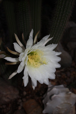
 The blooms are the size of an adult's hand span.


 The blooms are the size of an adult's hand span.
Wednesday, June 10, 2009
MAY/JUNE CONDITIONS ON MT. WHITNEY
For those of you interested in trying to climb Mt. Whitney this spring you should be aware of current conditions, and more importantly how to interpret those conditions to help you decide how to make decisions with safety in mind.
Snow is still present on Mt. Whitney left over from the winter. You can count on negotiating a snow covered trail from somewhere above Trail Camp until Trail Crest and possibly farther. From the cables until Trail Crest there are hazardous areas where a slip can turn into a fall that can lead to an injury or fatality. This section is part of what most of us refer to as the “97 Switchbacks”. The weather has been unstable since the last week in May. This coupled with the fact that the 97 switchbacks are on a north facing slope between 12,400' and over 13,600' means the snow will not melt off quickly until temperatures warm up.
Given these conditions there are certain things to keep in mind if you decide to attempt climbing Mt. Whitney via the Main Trail. This list is not exhaustive but is a good place to start:
(1) Recognize that your ascent will take longer than it would if the trail was dry. Plan extra time into your itinerary to account for this.
(2a) Realize that current conditions require climbers to have learned and practiced several mountaineering skills which include self arrest with an ice axe (this is how you would attempt to stop yourself in the event of a slip on the hard snow and ice), how to walk with crampons on, and how to efficiently climb up and down snow covered slopes.
(2b) This means that ski poles are no substitute for an ice axe. Ski poles are great aids in walking. Ascending a route they are like a portable hand rail. On a descent they help reduce some of the jarring to hiker’s knees. They will do nothing to help stop a person in case of a fall. Yes, some ski poles are made with self arrest grips. This is no substitute for an ice axe.
(3a) The slope between Trail Camp and Trail Crest is north facing. This means it loses sun exposure early in the day. You can be on this slope during a warm sunny day and find the snow comfortable to walk on, but once the sun leaves this slope the snow will become firm, hard, and slick. It will stay that way until the sun hits it again, which might be the next day, or it might take several days if clouds obscure direct rays from the sun. Even with direct sun exposure the conditions could still be firm, hard, and slick.
(3b) Be prepared to climb on firm, hard, and slick snow. If you find yourself on this slope after the sun begins leaving this area you need to be prepared to negotiate increasingly firm, hard, and slick snow conditions.
(4a) Sliding down the snow on your butt (commonly called “glissading” among the mountaineering community) from Trail Crest is not a safe option. It doesn’t matter if you see tracks from people who have previously done it. Among those who contributed to glissade tracks in previous seasons include several people who lost their lives from the decision to glissade there.
(4b) People have tried glissading here for years. Understand that this slope is subtly angled in such a way that it can pull an unsuspecting mountaineer slowly to the left, which can make you slam into the rocks at a high rate of speed. There have been many injuries and even fatalities due to people glissading here.
(4c) If you decide to glissade anywhere on any mountain, remove your crampons. Glissading with crampons is never an option. You run a high chance of injuring an ankle, a leg, or worse. It is extremely poor mountaineering technique to glissade while wearing crampons anywhere at any time.
(5a) Remember that the summit should not be your primary goal. Your first goal is to get back to the parking lot safely. If you can stay within a good margin of safety, then the summit should be your second goal. This means that just because somebody else decided to ascend in questionable conditions it should not determine what you decide to do. You need to make your decisions based on your known skills and the ability of your group.
(6) There have been reports of people leaving crampons and ice axes in their cars because people down below told them they weren't needed or were too dangerous for the inexperienced. Don't take that advice at face value. Ask questions about conditions and get reports from as many people as possible. If in doubt, don't leave the gear behind. It's better to take it and not need it than the other way around.
Sunday, June 07, 2009
CHILNUALNA FALLS
Chilnualna Falls. What a beautiful trail.
We hit the trail at 9:00 a.m. A very late start by our standards, but we were in no hurry to do anything today. In fact, we woke up and said, "Let's go for a hike in Yosemite."
Loaded up the wilderness daypacks with our 10 Essentials. Gassed up at Vons while Pam got the sunscreen at Long's (she forgot where she put her organic sunscreen). Caffeined and croissanted up in Oakhurst and off we went.
We have never hiked Chilnualna, so we thought it would be best to hike it now since the temperatures are way below normal for this time of year due to the unseasonal storms in the area and the area is still green and the creeks and rivers are overflowing due to the snow melt.
Although marked "strenuous," it didn't seem like it. The only strenuous part was from the start of the "staircase" alongside the first cascade. After that, it was a fairly decent hike. We started under clear skies, but as we neared the halfway point, clouds formed overhead. No threat of rain, but the temperatures did drop noticeably while we were standing on the exposed rock.
We never saw any wildlife except for an occasional bird and squirrel.
We encountered very few people along the way.
After our hike, we stopped at the Wawona store to feast on ice cream drumsticks and tortilla chips and salsa. I ate the drumsticks. Chips and salsa were way too much for my tastes after a hike. Now, an order of fries and a chocolate shake would have hit the spot.
 The first cascade up. A series of stone steps like Vernal Falls takes you almost straight up.
 Signs, signs, everywhere there are signs.
 Somebody forgot something.
 All to ourselves.
 Water seeping from the granite.
 We will probably run this trail next time.
 Well-maintained trails.
 Ahhhhh...taking it all in.
 Mist of the Falls.
 Photo opportunity time.
 Ditto.
 A snowmelt creek.
 From another angle.
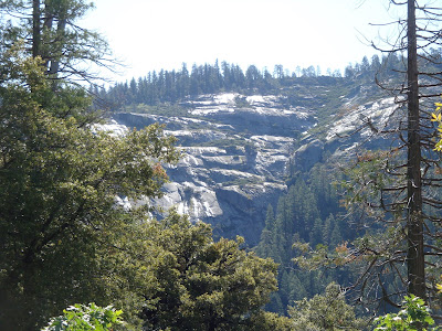
 Wawona Dome.
 Up and up...
 Almost there.
 Beyond here, takes you...
 Here with more trail to go.
 Then a little further up the trail...
 Absorbing the roar of the falls.
 This is where we turned around.
 As we like it! Very few flying and biting insects.
 The Wawona Valley down below.
 Another view.
 Erosion marks in the granite. I imagine there is a scientific term for this, but...
 A lot of water flowing this time of year.
 It doesn't get any better than this.
 Same falls, different angle.
 Now, if it were really hot...
If you are ever in the Yosemite National Park area, this is an 11.2 mile must-do hike. Start early and you will probably have the whole trail to yourself. There are toilet facilities at the trailhead. If you forgot anything, chances are the Wawona Store may have it. Bring sunscreen and bug repellant. Bring at least 1 liter of water and some snacks. If you have a water filtration system, there is plenty of water along the way. If you plan to backpack, you must obtain a wilderness permit. And remember, Pack It In, Pack It Out.
The next hike we would like to do is the Alder Creek trail hike which is in the general vicinity of Wawona.
 Wherever I may roam...
We hit the trail at 9:00 a.m. A very late start by our standards, but we were in no hurry to do anything today. In fact, we woke up and said, "Let's go for a hike in Yosemite."
Loaded up the wilderness daypacks with our 10 Essentials. Gassed up at Vons while Pam got the sunscreen at Long's (she forgot where she put her organic sunscreen). Caffeined and croissanted up in Oakhurst and off we went.
We have never hiked Chilnualna, so we thought it would be best to hike it now since the temperatures are way below normal for this time of year due to the unseasonal storms in the area and the area is still green and the creeks and rivers are overflowing due to the snow melt.
Although marked "strenuous," it didn't seem like it. The only strenuous part was from the start of the "staircase" alongside the first cascade. After that, it was a fairly decent hike. We started under clear skies, but as we neared the halfway point, clouds formed overhead. No threat of rain, but the temperatures did drop noticeably while we were standing on the exposed rock.
We never saw any wildlife except for an occasional bird and squirrel.
We encountered very few people along the way.
After our hike, we stopped at the Wawona store to feast on ice cream drumsticks and tortilla chips and salsa. I ate the drumsticks. Chips and salsa were way too much for my tastes after a hike. Now, an order of fries and a chocolate shake would have hit the spot.
 The first cascade up. A series of stone steps like Vernal Falls takes you almost straight up.
 Signs, signs, everywhere there are signs.
 Somebody forgot something.
 All to ourselves.
 Water seeping from the granite.
 We will probably run this trail next time.
 Well-maintained trails.
 Ahhhhh...taking it all in.
 Mist of the Falls.
 Photo opportunity time.
 Ditto.
 A snowmelt creek.
 From another angle.
 Wawona Dome.
 Up and up...
 Almost there.
 Beyond here, takes you...
 Here with more trail to go.
 Then a little further up the trail...
 Absorbing the roar of the falls.
 This is where we turned around.
 As we like it! Very few flying and biting insects.
 The Wawona Valley down below.
 Another view.
 Erosion marks in the granite. I imagine there is a scientific term for this, but...
 A lot of water flowing this time of year.
 It doesn't get any better than this.
 Same falls, different angle.
 Now, if it were really hot...
If you are ever in the Yosemite National Park area, this is an 11.2 mile must-do hike. Start early and you will probably have the whole trail to yourself. There are toilet facilities at the trailhead. If you forgot anything, chances are the Wawona Store may have it. Bring sunscreen and bug repellant. Bring at least 1 liter of water and some snacks. If you have a water filtration system, there is plenty of water along the way. If you plan to backpack, you must obtain a wilderness permit. And remember, Pack It In, Pack It Out.
The next hike we would like to do is the Alder Creek trail hike which is in the general vicinity of Wawona.
 Wherever I may roam...
Wednesday, June 03, 2009
FUJI FOCUS
It won't be long until Pam and I board a plane to Japan to see my mother and to take in the culture of Japan. Pam has never been there. I have not been there since 1974. Thirty-five years is a very long time. Many of my relative weren't even born yet since my last visit. A stranger in a relative sea.
The highlight of our trip will be to summit Japan's highest mountain, Fuji-san (12,388 feet; 3,776 meters). We only have a small two-day window to attempt a summit. We want to start at the right time to be at the summit at sunrise.
The month of May was a "lost" month as far as conditioning goes. With the Social Security move, our physical conditioning program took a backseat hiatus.
Now, it is June. We have re-started our regimen. Hikes with heavy packs. When without packs, we sprint the uphills and glide the downhills. Intense weightlifting workouts concentrating on leg strength. Squats, leg presses, leg extensions, leg curls. Also, must workout the upper body as well with pullups, pulldowns, bardips, vertical knee raises, curls, rows, extensions.
The sweat pours, muscles ache. We are paying for the price of our neglect.
After commuting 90 minutes and working a full day, we are tired at the end of the day. But we keep reminding each other we got to do this and do this now just like we did for Mt. Whitney last year. Once before...we can do it again.
Fuji-san is only 12,388 ft (3,776 m). Mt. Whitney's Trail Camp is a little over 12,000 feet so we have no cause for concern. We just have to squeeze in some acclimatization hikes in Yosemite and there are plenty of hikes above 10,000 feet.
I already know that we will not be the only ones on the mountain or its summit. Every day, at 3,000 hike its slopes. There is no quota system like Mt. Whitney. I am sure we will be rubbing elbows with a lot of people.
Our prize will be the coveted branded hiking stick. Each station you pass you get a brand. Don't know how many brands, but we look forward to getting that souvenir.
Questions, questions, questions...
What is the weather like? What route will we take? How long will the hike take? When do we start? Will we need cold weather gear? What type of pack to bring? Ice axe? Crampons?
I know the answers...
An ice axe and crampons will not be needed.
All of the trails to the summit are well-marked.
The hike should take 8 hours roundtrip at most.
I would like to start around midnight, but there are other options to enjoy the mountain. We got two days. Might as well enjoy.
I feel it would be sufficient enough just to bring the fleece wear as well as essential gear in case of inclement weather.
The Camelbak pack should be enough for all of our gear.
We will begin the pre-stage of our trip this weekend. We will take some of the items and place them in the wheeled duffel. I will be maintaining a checklist and double-checking it.
Sherpa me.
Subscribe to:
Posts (Atom)