I have binn told I is a "very well" riter and that I shude I have my "Mike Echo" storey publisht.
Truth iz I am AINT NOT a good riter. I just start from the hart or whatever comes too mind and lett it floe.
I must cunfess my vokabulary is very limitd, so I won't has you scurrying for the Rojay's Thawsawrus each and every time I rite in my blog.
Their, nuff sedd.
Thursday, August 25, 2005
Saturday, August 20, 2005
MT. SAN ANTONIO ("BALDY") (click here for more info)

Dead tree reference along on the San Antonio Road.

The Baldy Bowl Trail starts just past the little pine tree along the road on the right.

The Baldy Bowl Trail. There is a register about 50 yards into the trail to log in the date of your ascent and whatever comments you wish to make. Unfortunately, there was no pen or paper. By the way, notice there is no trail sign. Keep scrolling down for the new sign!

The Christmas Tree at the Ski Hut. This tree is adorned with Christmas ornaments. No one knows how it all got started. The ski hut is to the left in the picture.

The summit tree. Once you see this you are near the top of 10,064. You can see some of the trail to the right of the picture.

Summit time. Thank goodness for digital cameras!

Bagged again.

Kicking back at the summit and taking in the panoramic views. Santiago Peak (Saddleback) (5,687 feet) way in the background. It was very windy at the top. My estimate is that the winds were 20-25 miles an hour. It was an exceptionally clear late August day. I couldn't see the ocean due to the marine layer, but I was able to see the Sierra Nevada, Mt. San Gorgonio (11,501), San Jacinto (10,834), Edwards AFB. I did not don my cold weather gear. I decided it was best to take advantage of the rock windbreaks and sun dry myself.

Laura Bieser, Outdoors Club hiker. She joined me at the summit half an hour after I did. This is picture was taken along Devil's Backbone Trail on the descent. Mt. Harwood (9,552) is to Laura's left.

Look back up towards the summit. Going up to the summit from Manker Flats via San Antonio Road to Baldy Notch and then along Devil's Backbone is about 6.8 miles. There are steep sections along this route from Baldy Notch to the beginning of Devil's Backbone. Then as you make your final push to the summit, the last one-half mile or so is a very challenging climb. The Baldy Bowl Trail is 4.2 miles (add .9 miles from Manker Flats to the trailhead) and is somewhat of a challengin climb in itself with narrow trails with precipitous drops as well as large rocks and scree.

Laura at the "new" trailhead sign that wasn't there in the morning. So many hikers who are unfamiliar with the trail miss this trailhead. If you blink, you will miss it. The trail is well "camouflaged." This sign will help hikers who are new on the trails and are looking for adventure.
 Me.
Me.My first "solo" hike of Baldy via the Baldy Bowl Trail. It wasn't planned to be this way. I do not like hiking solo, but since this trail is well-travelled with hikers and summit runners I didn't see any harm of heading off on my own. I waited for another Outdoors Club member, Laura Bieser, who wanted to hike with me. The leader of this ODC hike wanted to start at 10:00 a.m., but I felt this too late in the day to start. Laura emailed me and said she would like to join me.
I arrived at Manker Flats just short of 7:00 a.m. I parked my truck and looked around to see if I could spot Laura's Range Rover. I did not see it anywhere. I waited and waited. Figuring that she may have changed her mind about the hike, I hit the trail at 7:20 a.m.
I took some photographs to use as reference points for other hikers who may read this blog and may want to hike the BBT in the future. As I turned up onto the trail, I heard my name being called. It was Kandace Dunbar, a fellow hiker and soon-to-be Whitney hiker (09/08/05), who was with her hiking party. She yells, "See you at the summit!" I reply, "Maybe."
I stopped at the registry to sign in with my name and date and to make comments. To my dismay, there was a spiral notebook with no paper and there was no pen to be found. Oh well. I got a hill to climb.
Portions of the BBT are a bit difficult, but with trekking poles in hand, the ascent is not that foreboding.
I reached the Ski Hut at around 8:38 a.m. I stopped to take a picture of the Christmas Tree with its holiday ornaments. The tree is immediately off trail as you depart the main trail and head towards the hut.
After about a minute of rest and photo opportunities, I proceeded up the trail. At the rate I was going, I figured I was going to make great time. I paced my way to the summit. There are a lot of switchbacks from the ski hut to the summit. There was not snow on the ground near the summit like last time. Sometimes snowpack can be your best friend. Straight up instead of switchin back. The main drawback is that your calves burn going the direct route.
I reached the summit at 9:55 a.m. A little over two and a half hours! Not bad considering it took me and Mark Garvin 4 hours to hike this same trail back on June 25 (Garv is a slow ascent hiker). There wasn't too many hikers on the summit. I figured there would be more showing up at the summit around noon.
I asked a hiker to take my picture. I commented on how much snow was up here in the mountains back in late June. Many hikers inquired about the surrounding peaks. I obliged in telling them the landmarks. I pointed out to them the Sierra Nevada.
I decided to hunker down behind the rock windbreakers that can be found at the summit. I waited for Kandace to come up from DBB. About a half hour at the summit, I spotted Laura and invited her over my cozy spot.
I left the summit with Laura at 10:55 a.m. I was debating about going back down the BBT. But Laura was going down DBB so I went went with her. About 300 yards from the summit, I spotted Kandace and her daughter, Ashley. Borrowing a line from movie, "Silence of the Lambs," I said to Kandy, "We have to stop meeting like this...people will think we are in love!" Kandy will be making her first Whitney summit attempt on September 8, 2005. She is getting in the last acclimatization hikes in before her big day.
We saw a lot of hikers going up. Many were asking questions as to how much further. Instead of telling them the mileage, I told them they were "one hour," or "an hour and a half." Some hikers relished the challenge before them, others lamented.
We reach Baldy Notch a little after noon. After a "pit stop" it was time to make our final descent. We took a steep short cut from Baldy Notch down to the San Antonio Road. I was lead. Laura falls down but she is okay. I fall down and I was okay. As I was leading, I was kicking up dust that poor Laura was having to breathe in. I asked her if she wanted to lead, but she said that a little dirt is "good for you."
I was going to point out to Laura the landmarks that mark the BBT trailhead. Up ahead I spotted a brown sign that wasn't there this morning. Someone had put up a trailhead marker. This will be great for other hikers unfamiliar with the trail. I figure after the next winter storms, that this sign will be snowplowed over or destroyed.
We finished at 1:30 p.m.
The 11.9 mile hike took me five and one-half hours (not counting my one hour at the top)! Not too damn bad! The only post-hiking issue I had was that my right middle toe had a friction blister that broke. I remember the burn coming down to the steep descent the last one-half mile to Baldy Notch. That was strange. These are the same shoes I wored to Mt. Whitney in August 2004. I also wore the same wool socks and wool liners. I did not tighten my laces enough to prevent slipping within my boot. Lesson learned.
Saturday, August 13, 2005
SAN BERNARDINO PEAK
Click on the title to know more about San Bernardino Peak.
 The view from Manzanita Springs
 In 1852, Colonel Henry Washington and his Army survey party were directed to erect a monument atop San Bernardino Peak. The monument was to be an east-west reference point from which all future surveys of Southern California would be taken.
 Washington Monument survey point.
 Saturday, August 13, 2005 at 1:39 p.m.
Bagged another one. All 10,649 feet of it via the San Bernardino Peak Trail from the Angelus Oaks trailhead on Saturday, August 13, 2005. This was a spur of the moment hike. A woman posted on the San Gorgonio Wilderness Association website looking for someone to hike with. I obliged. It took us 9 and a half hours to hike the 15.8 mile roundtrip hike. We started at around 8:00 a.m. and finished at 5:30 p.m. My hiking partner took Diamox for this hike. The weather conditions were ideal. Some clouds were forming but were of no concern. The smog did envelope the Inland Empire area. However, I was able to view San Gorgonio, San Jacinto, Saddleback and Baldy. I met 4 hikers who were training for their Mt. Whitney hike on Friday, August 26. One of the hikers was on Mt. Whitney last year about the same time I was. I wished them the best of luck on their trip.
In my opinion, this trail is THE TRAIL to train for Mt. Whitney. The elevation gain is over 4,700 feet and the trails are similar to Whitney's. This trail would be ideal to train with a heavy pack (25-35 pounds) to get the legs stronger.
I recommend an early start. Be sure to fax in your permit application to the Mill Creek Ranger Station and have them leave it out overnight at the ranger station. I was fortunate enough to have a wilderness permit application with me. I filled in the required information and left. There were no extra applications out front. There were as many as 10 hikers waiting for the ranger station to open. I couldn't help but notice the office hours were from 6:30 a.m to whatever. It was 7:30 a.m. and the doors still weren't open. Must be on Hawaii time.
There is a watering point past Limber Pine at Limber Pine Springs. There was enough water trickling alongside the trail. There were no other watering points along the way. Insects were of no concern. We did not see much of the wildlife except for a chipmunk or two and a few lizards and crows.
Gear: 10 essentials along with Camelbak pack with 100 oz. bladder, trekking poles, boots, wool socks, gaiters, convertible pants, long-sleeve wicking shirt, wide-brimmed hat, Nalgene bottles, bandana, sunscreen, extra socks, toilet paper.
Wednesday, August 10, 2005
I COULDN'T HAVE SAID IT BETTER
"The mastery of all things including winning is brought about by a trinity of mind and body connection combined with a focus and blinding passion. The trinity of success is no big secret it simply requires effort and persistent determination. The trinity is a combination of correct thought, burning passion and dedicated effort. Without that formula both mastered and enacted you will only ever attain better than average. If you live by the rule of the trinity you can and you will attain greatness in any endeavor you put your mind to. Everything that happens in the entire material world and everything created within it is only an exteriorization of thought combined with effort to achieve the desired result. It's so simple it's almost ridiculous but it's true."
I think this says it all.
Like I said before Positive Mental Attitude: If you think a thing impossible, you will make it impossible.
Rick Collingwood
I think this says it all.
Like I said before Positive Mental Attitude: If you think a thing impossible, you will make it impossible.
Tuesday, August 09, 2005
EPILOGUE

Someday, Garv, Mt. Whitney will be yours.
Garv came within 3 miles of reaching the summit before turning around.

Many, many thanks to friends, family, and strangers. Your words of encouragement worked wonders.
Two out of three summit attempts for the year ain't that bad. I shouldn't count the June 3-day hike due to it being a three-dayer and I hyperextended my knee. I am oh-fer for the multi-day. Now as for the 1-dayers, I am 3 for 3. I like those numbers.
Planning in the works for a hike for Saturday, August 20, up to Mt. Baldy via the Ski Hut Trail. It was for August 13, but due to scheduling conflicts it has been changed. The training never stops.
Saturday, August 06, 2005
FRIDAY, AUGUST 5

At the Whitney Zone. Garv on the left and Joe on the right. I think that is Jonathan between the two. Cisco is behind Joe out of flash range.

Sunrise on the 99s around 6:00 a.m. That dark spot in the center is where Trail Camp is located. I am approximately 800 feet above. The White Mountains are in the far background. The sun is just barely rising above the crest.

8 down, 3 to go! I am approximately less than a half mile from Trail Crest. I happened to spot this by accident as I was looking down. I was having a hard time finding this rock in my viewer so I laid down my trekking poles as a reference and voila!

The summit register:
08/05/05 1 Day x 3 I did it again, again, again.
Mr. and Mrs. Beasley in the capsule. The lucky penny from Brian. My word is my honor. Mission accomplished. Wishes fulfilled.

Jonathan Stouffer at the sign on the summit. Due to the gathering storm, he was only allowed to stay almost 5 minutes at the summit. I think his smile says it all.

Waterfall sculpture. Darth Vader in white?

Trailside Meadow looking west.

Above timberline

Mirror Lake

Timberline

Big Horn Sheep Park and Outpost Camp.

Doe...A deer...female deer...at Outpost Camp.

The Four Summitteers: Me (3rd summit), Cisco (1st summit 1st try), Jonathan (1st summit 1st try), Joe (3rd summit a day after his 59th birthday)
12:00 a.m.
Start. Me, Jonathan S., Francisco R., Joe M., Mark G.
12:19 a.m.
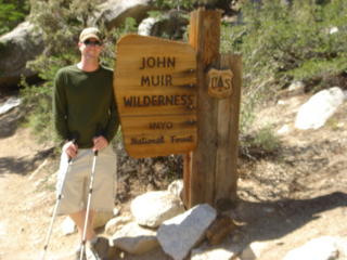
We reach the John Muir Wilderness sign.
1:27 a.m.
We reach the log crossing. Footing is tricky. Depth perception and peripheral vision lacking due to the headlamps that light the logs at our feet. One false move and splash. Swimming with the fishes.
1:32 a.m.
We reach the Whitney Zone. We stop and take a 5 minute rest before proceeding.
2:09 a.m.
We reach Outpost Camp. Two stream crossings before campsite. One crossing after the campsite.
4:30 a.m.
We reach Trailside Meadows. It got too quiet. We missed our water replenishing mark. We doubled back. I take Garv's 1-liter Nalgene bottle to fill up as he proceeds to Trail Camp. I top off my 100 ounce Camelbak bladder and fill up a Nalgene bottle. I have a problem with the water filter seal. Gasket sealing problems. Readjust the water purifier. All okay.
5:02 a.m.
We reach Trail Camp. I contemplate taking a nap. I am yawning all the way from Outpost Camp to Trail Camp. Not good. The group decides it wants to push on. I lead the way with Cisco behind me, followed by Jonathan, then Joe, then Garv. It is here we decided that everyone for themselves. We will not wait for each other. Go at your own pace. Good luck. Once at the 99s, I tell Cisco to go ahead. Same to Jonathan and Joe. I will see you at the top.
6:00 a.m.
I stop to take a picture of the sunrise while on the switchbacks. I look back. No sign of Garv.
7:00 a.m.
I reach Trail Crest. Cisco, Jonathan, and Joe are there. From here we proceed on. Cisco, Joe, me, Jonathan. There is a point in the trail where a rock blocks the trail. We gingerly descend down and around. I decide to glissade. Loose dirt and scree. One wrong step or slip and say hello to the bottom of the slide.
8:07 a.m.
Ennui. The last mile. Every 200 steps I stop and rest. I force air through my mouth as if I were playing a trumpet. Expand the lungs. Pace. Hydrate. I see Cisco and Joe up ahead. Cisco doing well. Joe is laboring, but he keeps pushing on. I lose sight of Jonathan behind me. I notice clouds rolling in from the east. I see clouds forming at the summit. Not a good sign.
8:44 a.m.
I see the hut. I am almost there. All systems are go.
8:48 a.m.
I summit. Cisco and Joe are already there. Jonathan later summits. Garv does not. I sign in at the register near the hut. It is difficult to concentrate on writing. I am cold. Altitude playing tricks with my thought processess. Cisco asking about the pit toilet at the top. Joe and I pose for a photo with his camera. I manage to take photos of the summit register and Jonathan. Pandemonium rules at the summit. Joe wants to leave the summit immediately. I concur with that assessment.
8:57 a.m.
Begin descent. Clouds thick at the summit. This is no place to be during a storm. Death is certain if struck by lightning.
10:00 a.m.
We reach that treacherous part of the trail where that rock is. Scrambling up. No foothold. Rocks falling beneath my feet. Traction minimal. I point out to Jonathan about the loose rocks and footing. He in turn does the same to Joe.
10:12 a.m.
We reach Trail Crest. Cisco proceeded on. Then me. Jonathan and Joe stay back for a little to catch their breaths.
10:13 a.m.
The 99s and heading down. A lot of hikers heading up. Traffic jam. Watching my footing on the way down. No slips.
11:29 a.m.
I reach Trail Camp. I sit down on a rock outcropping and open up a GU energy gel packet. It tastes awful, but I down it with my water. Need to replenish my electrolytes. I remember the last time I felt like when I was up here in July. Jonathan and Joe arrive just moments after me. We push on.
11:45 a.m.
I slip and fall on my backside. Boom! Thank goodness for the pack. No harm. Systems A-OK.
12:12 p.m.
Trailside Meadows. Heaven. Joe and Jonathan stop to replenish water supplies. I have an ample supply left in my bladder.
1:06 p.m.
We reach Outpost Camp. A doe takes an interest in our presence. We stop for one final time so that Joe can take his jacket off.
1:26 p.m.
We reach the Whitney Zone. I mention to Jonathan that this will be the LONGEST 2.8 miles. We hike at a brisk pace. Recon shuffle.
2:11 p.m.
We FINALLY reach the junction of the stock trail and the Mt. Whitney Trail. Three-quarters of a mile to go. It is just a matter of time.
2:27 p.m.
End hike. Total time 14 hours and 27 minutes.
We see Garv and Cisco outside by the Whitney Portal Store. We head down to our vehicles to drop off our gear and return to the store. Cisco dining on burgers and fries. Looks tempting. We buy our memorabilia at the Whitney Portal Store. I buy patches and stickers. Joe buys a Heineken. I am anxious to get off this mountain. I have seen enough. I am fidgety. Let's go. We need a shower and then we can celebrate!
We head back to Lone Pine for photo opportunities, to open up some barley pop, and to get showered up. Cisco leaves for home and bids us farewell.
The rest of us celebrate at Seasons. I have a steak. That was a very good steak!
We retire for the night around 6:30 p.m. The Angels game is on at 7:00 p.m. As soon as I my head hit my pillow...zzzzzzzzzzzzzzzzzzzzzzzzzzzzzzz.
12:00 a.m.
Start. Me, Jonathan S., Francisco R., Joe M., Mark G.
12:19 a.m.
We reach the John Muir Wilderness sign.
1:27 a.m.
We reach the log crossing. Footing is tricky. Depth perception and peripheral vision lacking due to the headlamps that light the logs at our feet. One false move and splash. Swimming with the fishes.
1:32 a.m.
We reach the Whitney Zone. We stop and take a 5 minute rest before proceeding.
2:09 a.m.
We reach Outpost Camp. Two stream crossings before campsite. One crossing after the campsite.
4:30 a.m.
We reach Trailside Meadows. It got too quiet. We missed our water replenishing mark. We doubled back. I take Garv's 1-liter Nalgene bottle to fill up as he proceeds to Trail Camp. I top off my 100 ounce Camelbak bladder and fill up a Nalgene bottle. I have a problem with the water filter seal. Gasket sealing problems. Readjust the water purifier. All okay.
5:02 a.m.
We reach Trail Camp. I contemplate taking a nap. I am yawning all the way from Outpost Camp to Trail Camp. Not good. The group decides it wants to push on. I lead the way with Cisco behind me, followed by Jonathan, then Joe, then Garv. It is here we decided that everyone for themselves. We will not wait for each other. Go at your own pace. Good luck. Once at the 99s, I tell Cisco to go ahead. Same to Jonathan and Joe. I will see you at the top.
6:00 a.m.
I stop to take a picture of the sunrise while on the switchbacks. I look back. No sign of Garv.
7:00 a.m.
I reach Trail Crest. Cisco, Jonathan, and Joe are there. From here we proceed on. Cisco, Joe, me, Jonathan. There is a point in the trail where a rock blocks the trail. We gingerly descend down and around. I decide to glissade. Loose dirt and scree. One wrong step or slip and say hello to the bottom of the slide.
8:07 a.m.
Ennui. The last mile. Every 200 steps I stop and rest. I force air through my mouth as if I were playing a trumpet. Expand the lungs. Pace. Hydrate. I see Cisco and Joe up ahead. Cisco doing well. Joe is laboring, but he keeps pushing on. I lose sight of Jonathan behind me. I notice clouds rolling in from the east. I see clouds forming at the summit. Not a good sign.
8:44 a.m.
I see the hut. I am almost there. All systems are go.
8:48 a.m.
I summit. Cisco and Joe are already there. Jonathan later summits. Garv does not. I sign in at the register near the hut. It is difficult to concentrate on writing. I am cold. Altitude playing tricks with my thought processess. Cisco asking about the pit toilet at the top. Joe and I pose for a photo with his camera. I manage to take photos of the summit register and Jonathan. Pandemonium rules at the summit. Joe wants to leave the summit immediately. I concur with that assessment.
8:57 a.m.
Begin descent. Clouds thick at the summit. This is no place to be during a storm. Death is certain if struck by lightning.
10:00 a.m.
We reach that treacherous part of the trail where that rock is. Scrambling up. No foothold. Rocks falling beneath my feet. Traction minimal. I point out to Jonathan about the loose rocks and footing. He in turn does the same to Joe.
10:12 a.m.
We reach Trail Crest. Cisco proceeded on. Then me. Jonathan and Joe stay back for a little to catch their breaths.
10:13 a.m.
The 99s and heading down. A lot of hikers heading up. Traffic jam. Watching my footing on the way down. No slips.
11:29 a.m.
I reach Trail Camp. I sit down on a rock outcropping and open up a GU energy gel packet. It tastes awful, but I down it with my water. Need to replenish my electrolytes. I remember the last time I felt like when I was up here in July. Jonathan and Joe arrive just moments after me. We push on.
11:45 a.m.
I slip and fall on my backside. Boom! Thank goodness for the pack. No harm. Systems A-OK.
12:12 p.m.
Trailside Meadows. Heaven. Joe and Jonathan stop to replenish water supplies. I have an ample supply left in my bladder.
1:06 p.m.
We reach Outpost Camp. A doe takes an interest in our presence. We stop for one final time so that Joe can take his jacket off.
1:26 p.m.
We reach the Whitney Zone. I mention to Jonathan that this will be the LONGEST 2.8 miles. We hike at a brisk pace. Recon shuffle.
2:11 p.m.
We FINALLY reach the junction of the stock trail and the Mt. Whitney Trail. Three-quarters of a mile to go. It is just a matter of time.
2:27 p.m.
End hike. Total time 14 hours and 27 minutes.
We see Garv and Cisco outside by the Whitney Portal Store. We head down to our vehicles to drop off our gear and return to the store. Cisco dining on burgers and fries. Looks tempting. We buy our memorabilia at the Whitney Portal Store. I buy patches and stickers. Joe buys a Heineken. I am anxious to get off this mountain. I have seen enough. I am fidgety. Let's go. We need a shower and then we can celebrate!
We head back to Lone Pine for photo opportunities, to open up some barley pop, and to get showered up. Cisco leaves for home and bids us farewell.
The rest of us celebrate at Seasons. I have a steak. That was a very good steak!
We retire for the night around 6:30 p.m. The Angels game is on at 7:00 p.m. As soon as I my head hit my pillow...zzzzzzzzzzzzzzzzzzzzzzzzzzzzzzz.
Friday, August 05, 2005
THURSDAY, AUGUST 4
HAPPY 59TH BIRTHDAY, JOE MAGRUDER!
Jonathan Stouffer
Tax & Financial Group
Francisco "Cisco" Rodriguez
Outdoors Club
After having breakfast at the High Sierra Cafe, I take Cisco and Jonathan to Whitney Portal. Garv stays back at the motel.
As we drove up Whitney Portal Road, Jonathan and Cisco were very anxious. They couldn't believe that they would embark on the hike of their lives.
They were in awe of the Whitney Portal area.
Before heading out on the familiarizaton hike, we stop by the Whitney Portal Store to look around.
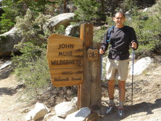
We then take off heading up trail reaching the John Muir Wilderness. Both were mesmerized by the beauty of the place.
We then descended along the Mt. Whitney Trail.
We crossed the North Fork Lone Pine Creek and took a detour up the Mountaineer's Route to survey that trail.
After reaching the trailhead, we put away our hiking gear and view the falls.
We return to the Whitney Portal Store and I ordered two orders of the infamous Portal Fries for the three of us. We leave some for Garv.
We headed back down to Lone Pine in time to watch the Angels baseball game at 1:00 p.m. It is hot in Lone Pine. Temperatures in the high 90s.
I try to squeeze in a catnap, but to no avail.
Joe Magruder arrives shortly thereafter.
All team members present.
We have dinner at the Totem Cafe. We go over the checklist making sure everyone has what they need as we wait for our food. Cisco needed to get sunglasses. We are a go.
We return to our rooms and hit the lights around 6:30 p.m. hoping to squeeze in 4 hours of sleep. We set all alarms making sure we will not miss our marks.
We wake up at 10:30 p.m. I managed to sleep intermittently for 2 hours.
Garv gets me a cup of coffee from the High Sierra Cafe. I down a quart of Gatorade and eat two chocolate-covered macadamia nuts for "breakfast." Might as well get sated and hydrated.
We meet in the motel parking lot. People swimming in the pool. People leaving the Pizza Factory. What is wrong with this picture? Everyone relaxing in the evening air. Everyone going home for the night. We are not them. Our day of days is just beginning.
We drive up in separate vehicles to Whitney Portal around 11:30 p.m. I take Garv and Jonathan in my truck, while Joe and Cisco drive their vehicles.
The skies were clear. We were able to park near the Mt. Whitney trailhead sign.
Around us, there was nothing but pitch blackness.
Above us, there was a canopy of stars.
Before us, there was a hike of a lifetime.
Time on deck...11:59 p.m.
We prepare to move out...

Jonathan Stouffer
Tax & Financial Group

Francisco "Cisco" Rodriguez
Outdoors Club
After having breakfast at the High Sierra Cafe, I take Cisco and Jonathan to Whitney Portal. Garv stays back at the motel.
As we drove up Whitney Portal Road, Jonathan and Cisco were very anxious. They couldn't believe that they would embark on the hike of their lives.
They were in awe of the Whitney Portal area.
Before heading out on the familiarizaton hike, we stop by the Whitney Portal Store to look around.
We then take off heading up trail reaching the John Muir Wilderness. Both were mesmerized by the beauty of the place.
We then descended along the Mt. Whitney Trail.
We crossed the North Fork Lone Pine Creek and took a detour up the Mountaineer's Route to survey that trail.
After reaching the trailhead, we put away our hiking gear and view the falls.
We return to the Whitney Portal Store and I ordered two orders of the infamous Portal Fries for the three of us. We leave some for Garv.
We headed back down to Lone Pine in time to watch the Angels baseball game at 1:00 p.m. It is hot in Lone Pine. Temperatures in the high 90s.
I try to squeeze in a catnap, but to no avail.
Joe Magruder arrives shortly thereafter.
All team members present.
We have dinner at the Totem Cafe. We go over the checklist making sure everyone has what they need as we wait for our food. Cisco needed to get sunglasses. We are a go.
We return to our rooms and hit the lights around 6:30 p.m. hoping to squeeze in 4 hours of sleep. We set all alarms making sure we will not miss our marks.
We wake up at 10:30 p.m. I managed to sleep intermittently for 2 hours.
Garv gets me a cup of coffee from the High Sierra Cafe. I down a quart of Gatorade and eat two chocolate-covered macadamia nuts for "breakfast." Might as well get sated and hydrated.
We meet in the motel parking lot. People swimming in the pool. People leaving the Pizza Factory. What is wrong with this picture? Everyone relaxing in the evening air. Everyone going home for the night. We are not them. Our day of days is just beginning.
We drive up in separate vehicles to Whitney Portal around 11:30 p.m. I take Garv and Jonathan in my truck, while Joe and Cisco drive their vehicles.
The skies were clear. We were able to park near the Mt. Whitney trailhead sign.
Around us, there was nothing but pitch blackness.
Above us, there was a canopy of stars.
Before us, there was a hike of a lifetime.
Time on deck...11:59 p.m.
We prepare to move out...
Wednesday, August 03, 2005
WEDNESDAY, AUGUST 3
Garv and I head up to Horseshoe Meadows to hike the Cottonwood Pass trail to Chicken Springs Lake for an acclimatization hike. We go as high as 10,700 feet before turning around. The overall length of the hike was 8 miles. No major headaches. That's a good sign.
Later that afternoon, Jonathan Stouffer joins us to stay at the Dow Villa.
We dine at the Pizza Factory for pizza, spaghetti, and beer.
That evening, Francisco "Cisco" Rodriguez arrives around 7:00 p.m.
Joe Magruder is the only team member left. He will arrive tomorrow around 1:00 p.m.
Later that afternoon, Jonathan Stouffer joins us to stay at the Dow Villa.
We dine at the Pizza Factory for pizza, spaghetti, and beer.
That evening, Francisco "Cisco" Rodriguez arrives around 7:00 p.m.
Joe Magruder is the only team member left. He will arrive tomorrow around 1:00 p.m.
Tuesday, August 02, 2005
TUESDAY, AUGUST 2

Prophetic sign at Dow Villa Hotel/Motel
Yes, Mt. Whitney awaits...
Mark Garvin and I leave for Lone Pine around 8:00 a.m. and arrive around 1:00 p.m. We have lunch at the High Sierra Cafe before checking into the Dow Villa Motel.
After unloading our provisions, we head up to Whitney Portal. We go up the old stock trail to the John Muir Wilderness sign on the Mt. Whitney Trail.
The stock trail is approximately 3/4 miles in length and has 27 switchbacks. It is steep and poorly maintained.
This is the trail we will use since it bypasses the 3 stream crossings starting from the Mt. Whitney trailhead.
At the junction of the two trails, we meet 2 hikers who had been in the wilderness for over 220 miles. I told them take the stock trail to avoid the streams. They didn't.
We later met them at the Portal Store. One of them inquired about the yellow band (Livestrong) I had on my wrist. He asked who won the Tour de France and we told him.
Imagine being in the wilderness for weeks without any contact with the outside world except those other hikers you meet along the way. Fascinating. Isolation. Severing ties with the outside world without a care. Enjoying the wilderness. Yes, I would like that.
Monday, August 01, 2005
OPERATION: C.H.E.E.R.S.

Click on the above title to the link on Mt. Whitney.
"Operation C.H.E.E.R.S.: Climbing, Hiking, Enjoying our Enthusiastic Romp to the Summit." -- Kandy
Thank you, Kandy Koyote ! Best of luck on your summit bid in a few weeks!
Here is another inspirational quote:
"Ability is what you’re capable of doing. Motivation determines what you do. Attitude determines how well you do it." -- Lou Holtz
Yes, here I go again...again for the final time this year.
This time it will be with my co-workers Garv and Jonathan, hiking partner and friends Joe and Francisco. I have one vacancy and I find it difficult to fill. Guess I will have to "eat it" or maybe there is someone in Lone Pine just waiting to get their chance. I hope my instincts are correct. The little things I do that have a tremendous impact!
I will be leaving for Lone Pine on Tuesday, August 2, and will return on Saturday, August 6. So no blog entries until I return. If I only had a laptop...
I want to thank all those who have hiked with me and inspired me to do this again again. Thank you for sharing your time and your experiences with me.
My heart goes out to Shelly and Kindra. I know how badly they wanted to hike to the top. I dedicate this hike to both of you.
Since reaching the summit of Mt. Whitney last August, I have logged over 575 miles in a little over 250 hours. I have trained harder, I have climbed longer. By endurance, I will conquer.
By endurance, we will conquer. PMA!
I also want to thank the people at:
Montrail, Marmot, The North Face, Outdoor Research, Mountain Safety Research, Garmin, Eagle Creek, Jetboil, Snow Peak, Smartwool, Wigwam, Nalgene, Camelbak, Gregory, Leki, Hi-Tec, Leatherman, Primus, Canon, Sony, Casio, Brunton, GSI Outdoors, Coghlan's, Mars, Hershey's, Garcia, Julbo, Trek, Performance Bicycle, Grivel, Petzl, Teva, PacificHealth Laboratories, Oregon Freeze Dry, Nike.
Last, but not least:
Mother Nature for her rain, wind, breeze, snow, ice, dust, mud, mist, heat, chill, lightning, thunder, tornadoes, black flies, rabbits, chipmunks, squirrels, birds, rattlesnakes, marmots, pikas, gopher snakes, habus, hornets, wasps, mosquitos, arroyo toads, scorpions, leeches, cockroaches, bears, coyotes, sand fleas, lizards, tarantulas, ticks, poison oak, cacti, artichoke thistle, yuccas, manzanita, pine trees, oak trees, boulders, rocks, rock slides, sand, scree, talus, mountains, valleys, waterfalls, streams, creeks, rivers that I have encountered on my travels. I am a guest in her house and I just wanted to thank her for her "hospitality" and for leaving the door open for me. Oh, almost forgot...Mt. Whitney for being so close and so high! I like that!
Time to have fun again...again.
Subscribe to:
Posts (Atom)