This morning, I received an email from BJ's family who are visiting relatives in Kansas.
BJ died on Monday, June 13. The day I was at Trail Camp while watching my friends assault the snow chute to Trail Crest while I stayed back.
He was 10-years-old.
And to think Father's Day was June 19.
My heart goes out to Bob and Vicky and Brian. BJ is in a better place.
I bet BJ and "Mike Echo" are probably having fun right now.
Today will not be a very good day.
Wednesday, June 29, 2005
Saturday, June 25, 2005

OH WHAT A FEELING
Saturday, June 25, 2005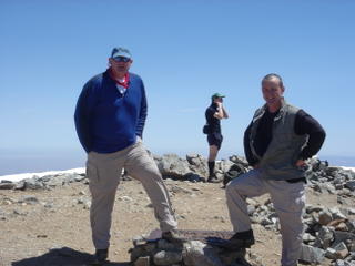
Summit. Garv and I reached the top of Mt. San Antonio ("Baldy"). It was his first summit of 10,064 foot peak.
Trails were excellent. There was snow near the top but it just made the hike that more enjoyable.
The Ski Hut Trail is by far the best trail to get in condition for any hike whether it be San Gorgonio or Whitney. With its steep ascents and switchbacks, it is a trail that will reward you once you reach the top!

Tuesday, June 14, 2005


MT. WHITNEY JUNE 14, 2005
I get up around 5:30 a.m. just in time to see the sunrise.
I am anxious to leave, but not anxious to leave this godly place. I wish I could take this place with me. I can't.
My anxiety is the 4 hour drive back to the concrete and steel jungles of Los Angeles and Orange Counties. Reality. Had things been different back home, I would not be experiencing these remorse feelings. They say all good things must come to an end. True.
But before I leave, I have to break camp. Sleeping bag. Stuff. Tent. Roll. Mattress pad. Roll. Bear vault. Stuff. Clothing. Stuff. Stove. Stuff. Ice axe and crampons. Secure. Water bladder. Full. Water bottles. Empty. Trekking poles. Adjusted. Sunscreen. Applied.
As I am doing these things, Steve and Mark awaken from their slumber. They said as soon as they hit the bags, out went the lights. They were exhausted. They said it was the best sleep they had in years. Deservingly so. You earned it.
Brian and Eusebio awaken as well. Brian is still on cloud nine. Eusebio manages a smile. He looks tired.
Steve and Brian bid us farewell. Now that they have conquered the highest in the 48 they are off to go to the lowest of the 48. Death Valley at 282 feet BELOW sea level. We shake hands and congratulate them on a job well done.
We leave Outpost Camp at 7:06 a.m. to begin our "long" descent to Whitney Portal 3.8 miles away. I know of this descent. It is the longest 3.8 miles. The good thing is that it is downhill. The bad thing is that you are fatigued, sore, smell, and may have blisters on your feet. You wish you could just take an escalator down to the ground floor, go to your vehicle and drive away.
The water levels in these stream have risen significantly since Sunday. I guess the water level to be around one to two inches higher than a couple of days ago. We make it across all of them without incident. With the warmer temperatures, the snow melt will accelerate. Many hikers await I am sure.
About a half mile or less from the end trailhead, the trail switches back towards the east. If you look up you can see Mt. Whitney. I turned around and pointed it out to Brian. He stopped in his tracks to gaze upward. There is this smile on his face. "Hey, Brian, you were up there! Eusebio, you will get your chance next year!"
The mountain air now becomes civilized air. The smell of smoke. The smell of bacon. Ah...
We arrive at Whitney Portal around 9:00 a.m. I weighed my pack again on the spring-loaded scale. Fifty-five pounds!
I change...check that...I shed/peel out of my camping clothes into some nice clean ones. I take off my shoes, socks, braces and stuff them into the stuff sack. This is some really dirty laundry. I debate whether to hit the road or eat a Portal Pancake. I imagine my body odor was enough to scare any bear away, but it didn’t matter. I don't care how I smell or appear.
I decide to have that infamous Portal Pancake. I know I will be back in July and August, but you never know who you will meet.
I bid Eusebio and Brian good-bye. I never knew them before the hike. Just strangers on a webpage who signed up to hike. I will not forget them. I hope to see them some day on another Outdoors Club adventure.
I walk into the store and order my pancake. I am so hungry I can eat a Portal Pancake in its entirety.
I notice a gentleman sitting down eating his breakfast. I ask, “Are you Doug, Sr.?” “Yes,” was his reply as he stood up to shake my hand. Doug Sr. is the proprietor of the Whitney Portal Store and is a wealth of information in his 20 years of operating the store. He also is the co-author of the book, Mount Whitney: Mountain Lore from the Whitney Store. It just so happened to be that his son, Doug Jr., was my chef. I chatted with both Dougs and they told me of some of the stories and cast of characters who visit the WPS. I had a good laugh. They are warm and very friendly people. Down home. Down to earth.
I told them of my two Iowa friends. As soon as I finished that story, Mark and Steve and their uncle enter the store. “That’s the 2 guys!”
I only eat half of my pancake. Man was that good. I am stuffed. I am happy. I finally got to eat the infamous pancake.
Eusebio enters the store to again wish me goodbye. "Next year, Eusebio! If I get a permit you will be the first person I will call! I promise you that!"
I bid both Dougs farewell and tell them I will see them again in July.
Time was around 10:00 a.m. I drive down Whitney Portal Road to Lone Pine Campground to check on the campsite for my July 12 hike. I will be checking in on July 7 and check out July 10 to check in to Dow Villa that afternoon. I talk to the camp manager, Pat. Nice old lady. We chatted for a while, then I told her I had to hit the road for the four hour trip. Before I left, I went by the campsite. Nice. Excellent location. Nice view of Whitney.
The time was 10:30 a.m. Time to return to “base camp.”
I arrive home at 2:45 p.m. I unpacked my things to put away or to air out (especially the sleeping bag!). I sprayed WD-40 on my crampons and ice axe and wiped away the excess.
Next on the agenda was that long awaited shower. The water invigorated my weary body and soul and brought me back to life.
My "almost victory" dinner was a leftover Arby's roast beef sandwich and a couple order of fries. I had to cook a fresh batch of rice because the other batch looked nasty. Once the rice was cooked, I zap both the sandwich and fries in the microwave. I also fry an over easy egg to put on top of my rice. I break the yolk and pour on the soy sauce. I do have weird eating habits, but that is me and that is how I got to become what I am.
Lessons learned: I will never forget to pack my Marmot rain gear. I will never take for granted a warm cup of coffee. I will never forget the new friends I made on this hike.
Did I have fun?
You're damn right I did!
Monday, June 13, 2005


MT. WHITNEY JUNE 13, 2005
"It takes a person who is wide awake to make his dream come true."
Roger Ward Babson (1875-1967), American financial statistician
I did not have a restful sleep. Too many logistical issues going through my head. Do I take it? Do I need it? What if? What if not? Trail conditions? Weather conditions? How am I? How will I? I am at the mercy of my own decisions. I am responsible for what I do or fail to do. Isolation. Desolation. Desperation.
I "awoke" at a 4:45 a.m. I gathered my gear and was ready to go. I ate 2 bite-sized Snickers bars for breakfast. I contemplated making some hot tea to jump start, but my main focus was to get ready for the summit. I figured the hike ahead would be enough jump start.
Around sunrise, Steve and Mark were getting ready. I went over to their camp to go over any last minute questions. Their uncle decided he would not go with us and that he would return to Whitney Portal. I looked at the attire Steve and Mark were wearing. Steve wore blue jeans, a jacket, a baseball cap, a wooden walking staff, Merrell boots. Mark was wearing shorts, three layers of cotton clothing, a pack, couple of water bottles, boots and a wooden hiking stick. They had no cold weather gear, no gaiters, no crampons, no trekking poles, no ice axe. I said to myself, "You gotta be kidding me! You are going to the top in that?" Well, whatever trips your trigger. These guys have no idea what they are up against!
I walked back to my tent passing by Brian and Eusebio were also getting ready. I can tell by the look in their eyes, they were anxious to get started.
I got all my gear together and donned my pack and was adjusting my poles. I was having a difficult time with one of my trekking poles. It would not lock to the desired length. This can't be happening! I tried all types of options and finally I got it to work. I looked at the group and asked, "Did someone say a prayer?" Steve answered, "I scratched my head!" "Good, it worked!"
We leave for the summit at 6:04 a.m. Again, I am the scout. Followed by Brian, Eusebio, Mark and Steve. We crossed the creek and headed up the switchbacks towards Mirror Lake. The sun cast its early morning orange glow on the mountains around us. Incredible.
We had to overcome some snow pack along the way to Mirror Lake (10,640 feet; 4.3 miles). Somewhere along the way, I missed the trail because I was so focused on the snow pack beneath my feet. We wound up along the banks of Mirror Lake. We weren’t supposed to be there. Took that wrong turn at Albuquerque!
Anyhow, it was a perfect photo opportunity. There was a log we had to cross to get back on the trail. One false move meant a nice cold soaking. I commented to Steve and Mark, "You don't see this in Iowa!"
After I crossed the log, I immediately started looking for the trail. I just so happened to look to my left and saw the trail and looked down and realized I was standing on it! Imagine that! I can see where we lost it. All I had to do was look to the left while on the snow pack on the way up and there it was.
We hit the trail again and made it up more switchbacks. I kept my eyes open for the trail. Scanning. Looking. When I hit the snow pack, I scanned some more, picked up the trail and went. I would tell the others to wait until I found the trail. There was no need for them to waste energy. Let me do the walking. You just stand there and rest and catch your breath while I "seek and destroy."
We pass the last tree along the trail. A whitebark stump at around 10,950 feet.
I see the avalanche up ahead that I read so much about on the Portal Store website. Wow. Glad I wasn't here to see it happen! Wouldn't be prudent!
I stop to gaze around before stepping on to the snow pack. Trailside Meadows (11,395 feet; 5.3 miles), formerly known as Ram Horn Park, does not exist. It is covered in snow pack. There are parts of the trail exposed up ahead, but I felt it was in our best interest to stay on the snow and make a bee line for Trail Camp.
It was a decision that changed my whole entire day.
As soon as my right foot hits the snow, I posthole up to my crotch and hyperextend my knee as it hits terra firma. Pow! Excruciating pain. A lot of obscenities with the "f" word. My first thought was this can’t be happening. Not now. Why me?
I recollected my thoughts and started thinking of a contingency plan. Do I turn around and go back now or do I proceed with my plan of attack? What about the others? Can they make it without me? My only hope was that there were no more future incidents involving postholing and that my knee will hold up to the grueling hike ahead. My friends ask if I were okay. "Pain is weakness leaving the body," was my battle cry. However, this kind of pain was not a weakness.
We proceeded up the sloshy snow pack. I pointed out to the group that the avalanche is a reference point on the descent to get back on the trail and eventually to Outpost Camp. There is another route straight down the snowfields to OC, but it is a route I am not familiar with.
Up. Up. Up. There was no end. You reach the top and there is another ascent. We stop along the way to put our crampons on.
I am writhing in agony. Every step with my right leg hurt. Factor in the altitude and it made matters worse. But I kept pushing. I am going to the summit with my new friends.
Off to the left is ice-covered Consultation Lake. Some have called it Constellation Lake and Consolation Lake. Damn, I forgot my ice skates! I am trying to take my mind off my agony. I do not let my friends see my face. They ask a question and I turn around gritting my teeth through labored breaths and respond to their questions with enthusiasm. They are relying on me. I am going to get them there.
I see the solar toilet facilty to the right. We are here! We have reached Trail Camp (12,040 feet; 6.3 miles) a little after 8:00 a.m. What a magnificent sight with all the snow.
There was a man and woman there. Greetings were exchanged. I dumped my pack on the dry ground and proceeded to do a survey of the area of the route ahead. I proceeded up to a point where I could see Whitney to my right two and one-half miles away. I took a picture. That's the objective.
I look back at the 99 switchbacks that lead to Trail Crest. About a third of the 99s are still covered in snow. The best route is a straight shot up 50° grade or more in the snow chute just right of the 99s. I see other hikers making their way up to the snow chute that leads to Trail Crest. I envy them. Do I? Yes! I am going. Failure is not an option.
I turn around to return to the others and offer my plan. By God we are going. Then my right knee postholed again. Only this time the pain didn't phase me. It woke me.
I am not going. I decide it was best that I not proceed any further. I didn't want to do any further damage to my knee or they would have to carry me to Whitney Portal and that would not be prudent. I tell my friends of my decision. They will have to go without me. My heart was heavy. They understood.
Instead of feeling sorry for myself, I give my friends a rundown of what lies ahead for them. I tell them about the 1,620 feet of elevation gain they will hike up the snow chute. I tell them about the 2.5 miles they would still have to cover to get to the summit once they get to Trail Crest (13,660 feet). I tell them to be careful as they make their way to the John Muir Trail. I tell them to continue to pace themselve. I tell them to yoga breath. I tell them to keep hydrated. I tell them to nibble on whatever they had to subsist on. I tell them to if they do not reach the summit by 1:00 p.m., turn around. I belayed that. I tell them if they do not reach the summit by 2:30 p.m., then turn around.
I shook hands with my four friends. To the summit and safe return.
As they left, a tear welled up in my eye. Not of sadness, but of joy. I am seeing four hikers in pursuit of a dream. The same dream I had last year. Off they went. They joined up with other hikers who decided to leave about the same time.
I take off my crampons. I grab a camp towel and fill it with snow. I hunker down in a campsite with my pack to my back as it rests against a man-made stone wall. I unzip my convertible pant leg and place the my field expedient ice bag on my knee. Cold. Very cold. Uncomfortably cold. But I keep reapplying. If you don't do this, Gary, you will have someone carrying you down.
I pull out a Clif bar and started nibbling on it while drawing water throught the tube from my Camelbak Unbottle in my pack.
I am not a very religious person, but somehow someway, the Person Upstairs has ways for me to tolerate my discomfort. There is chipmunk flitting here and there looking for a morsel of food. Its tail in the air as it scampers around the site. It draws nearer to me only to run back to the safety of the rock wall. This routine goes on and on. I chuckle. Then enters this huge marmot to my left. It is no more than two feet away from me. It is eating a peppermint chocolate candy left behind by a careless hiker or it was taken from someone's pack without their knowledge. It is gnashing away at its dessert. It occasionally pauses to survey what other foodstuffs are available. Then the marmot inches closer as it senses my Clif bar. Oh no you don't as I take my take the handle of my trekking pole and scare him away. I also notice a crow hopping among the rocks making its familar "caw" sound as it looks for food. To my right a grey-crowned rosy finch lands by my feet pecking away at the ground occasionally looking my way for a handout. All I can do is smile. My furry and feathery friends are keeping me entertained. I had forgotten all my troubles.
I then glance up at the 99s to spot my friends. They are about a third of the way up. I look at my watch. At the rate they are going, they will be cutting it close or they will never make it at all.
About 10:30, I thought it would be best to start back down. I am of no use here. I must return to Outpost Camp. But before I left, I had some unfinished business to attend to. I placed BJ’s lucky penny in an inconspicuous spot where I will pick up next time. I said hi to a friend’s mother and brother who have passed on. I hope they heard me. I said a prayer for my new friends. I thought about all my co-workers. Man, I wish I could make a documentary to take back and show to everyone.
I put on my crampons and head back down. Every step was a very painful experience. One step at a time. Slowly.
I pass one man hiking solo with trekking poles and snowshoes on his pack. "Will I need crampons?" "Yes, but you won't need those snowshoes."
Next, about 15 minutes later, two women. One of the women was having a very difficult time with the altitude. "You're almost there!" "You wouldn't happen to be lying to me?" I just gave her a smile and said to her, "You are closer than you think. Hang in there! One step at a time." Practice what you preach, Gary, practice what you preach.
I stopped to take a picture of Consultation Lake and to adjust the knee brace on my right knee.
I pick up my avalanche visual reference and proceed to descend along the trail. I gingerly cross the snow pack. I get to the trail and put away my crampons. They have served me well.
I followed the trail. Downhill. But going downhill is worse than going uphill. Different muscles, different techniques.
I reach a snow pack. Where is the trail? I lost the trail! I couldn’t see it. Couldn't find it. I scampered among the rocks looking for the trail. Is it there? No. There? No.
Finally, I found it. Problem was it was 30 feet below me and gimpy me was up here with a lot of granite in between. You know 30 feet is only ten yards. Walk on a football field and you will know. Look up 30 feet and its nothing. Looking down 30 feet? That's another perception! It's a long way down. If the trail were a pool, I would jump!
I slid on my rump down the rocks favoring my sore knee. The movie, "Touching the Void," entered my mind. I don't need a Joe Simpson episode here where he jammed his knee so hard it sheared the patellar plateau and his tibia and fibula were now neighbors with his femur. Simon! I gingerly made my way down being ever so careful. Whew. I made it.
I return to OC around 12:30 p.m. I dump my pack. Relief. I went into my bear vault and pulled out two pouches of instant soup and some generic naproxen for my pain. I grab my Marmot DriClime windshirt and wrap it tightly around my knee for comfort and protection should I fall. I cook my soup and take one pill. Contemplated two. Naw. Take one. Didn't want stomach distress.
After subsisting, I take my mattress pad and bivy sack from my tent and lay them in the shade of the pine trees. I place the bear vault below my knee for comfort. I close my eyes. I am exhausted. Thoughts are of my friends on the mountain. The cool breeze lulls me to sleep. A deep sleep.
I awaken around 2:00 p.m. from the sound of approaching hikers. My friends are back! It is not them but other hikers making their way up the trail towards Mirror Lake.
I get up and gather my things as I try to regain consciousness. After putting my mattress pad and bivy sack away I glance towards the western sky.
Clouds. Cumulus clouds. Ah, just the same clouds as yesterday and the day before. No need for alarm.
Wrong.
The clouds took to grey. This is not good. I am not a meteorologist but when I see white clouds turn grey, that means rain. And at this elevation, snow and even lightning is even possible. I decide to place some rocks under my tent fly to keep the water off my tent just in case it started to rain.
Where are my four friends? Do they know the warning signs of an approaching storm? Do they know what to do? I failed to tell them if they see storm clouds to head back down immediately.
You do not want to be on Whitney when a storm hits. Lightning. Snow. Freezing temperatures. Hypothermia. Death. Not a good way to die.
At 4:15 p.m. it rains. Not a hard rain, but the raindrops were huge as they pelted me. Soon the rain turned into miniature slush balls and caromed off my shoulders. I decided it be best to seek shelter in my tent and hope those “slush balls” do not turn into huge hailstones or I will have to seek shelter elsewhere in the rocks that surround the camp. I take pictures. The rain hitting my tent sounds like popping corn. I peek outside my tent through the fly. You can see the soft hail hit the ground and bounce. The sounds get louder as the rain intensifies. Then like that it stops. The sun shines through. Good sign.
Five o'clock still no signs of my friends. I look up at the trail. No one. Five thirty. I see hikers coming down. It is not them. I do not ask if they had seen my friends. Ones asks me if this is the trail to Whitney Portal. I remember the hiker. He was one of several who came up the snowy way and left the same time my friends did. I did not ask if they reached the summit.
Six o'clock. I spot a figure on top of the snow pack by the waterfall. It is Mark. Then, Steve appears. They glissade down the last 30 yards of snow pack. They are elated. They reached the summit at 2:30 p.m. and started down at 3:00 p.m. They tell me that Brian and Eusebio are about one hour behind them. Mark says Eusebio is not looking good.
And this is how legends are made. Mark and Steve reached the summit without the aid of crampons, gaiters, ice axe, or trekking poles. John Muir would have been proud.
Around 7:00 p.m., I see another figure. It is Brian. He sees me in my hunter orange knit cap. I give the thumbs up. He raises his trekking poles high in the air with a triumphant cry. He does not come down. He waits for Eusebio. Fifteen minutes later, Eusebio appears. Both glissade down. Brian first. Eusebio sheds his pack and slides it down. He glissades only to pass his pack on the way down. He uses his ice axe to climb up to retrieve it. I told him to put the pack back on and glissade. He did. I quipped, "Longest 12 hours of your life, huh!" They both managed to crack a smile.
Eusebio did not reach the summit. He told me he was just 15 minutes away from reaching the summit, but the altitude was starting to take its toll. He made the right decision to turn around. I can see disappointment in his eye. I told him that he should be proud of what he done and that very few people make it that far. I also told him that he made the right decision to turn around. Brian tells me of his triumph. I can relate to his emotions. It is a feeling you will never forget for as long as you live.
In the meatime, Steve and Mark have retired to the confines of their tent. I imagine they are fast asleep.
Brian and Eusebio prepare to cook their meals as I retire to my tent for the evening.
Thank you, God, for looking out after my friends. Yes, You do work in mysterious ways.
Sunday, June 12, 2005

Home Sweet Home at Outpost Camp. My REI Half Dome tent, Gregory Whitney pack with Grivel ice axe. I am sitting on a bear vault that is required for use by all 3-day backpackers. In the vault are all your food, drink mixes, medicines, toiletries, trash, etc. Anything with an aroma MUST be stored in these vaults. If you do not have one, the ranger will ask you to leave. By the way, the WAG bags must be stored in here as well. One must be careful not to pull the wrong pouch out for a midnight snack and add hot boiling water while stirring contents and sampling the goods in total darkness. Wouldn't be prudent.


Solar toilets at Outpost Camp. Closed perhaps permanently due to rangers wanting hikers/backpackers to use waste alleviation and gelling (WAG) bags. You are given one per member of your team at the ranger station when you pick up your permit. A WAG bag is a trash bag filled with a chemical that will gel urine and control fecal odor. Once you finish your business, tie a knot in the bag and place in Ziploc bag provided. Squeeze air out GENTLY! Be careful not to tear a hole or you know what! If you have to go again, untie the knot and do your thing and repeat the process. These are multi-use up to 3 or 4 times. There is a dumpster at the Outpost Camp site to dispose. However, if you are along any portion of the trail, you poop it out, you pack it back! Towelette and toilet paper provided.


On the way to Outpost Camp. That is Lone Pine Lake. In the background are the Alabama Hill where many of the great black and white westerns were filmed. Gunga Din, The Cisco Kid, The Lone Ranger. See the big rock lower right along the snow line at lower right? Go left and down until you see another rock that seems to be touching the tree and go a little more to the left adn you will see another rock right at the edge of the snow line. That's TWZ! If you look closely, you can see the signpost just to the left of that branch and right next to the snow line. This is also the spot where Lawrence "Wrong Way" Murphy took his "nap" last August.


MT. WHITNEY JUNE 12, 2005
Rise and Shine...
We start our hike for Outpost Camp (3.8 miles; 1,995 feet elevation gain) at 7:00 a.m. At the trailhead there is a scale to weigh your packs. Brian weighed his. Forty-pounds. Eusebio weighed his. Forty-five pounds. Mine weighed a whopping 65 pounds. Enough frivolities. Let’s go kick some Whitney ass!
I am the lead. Brian is in the "rocking chair" and Eusebio is the red lantern. I am going at a slow pace. At least I thought I was. Several times we had to stop. I was fine, but Brian and Eusebio were having some difficulty with the altitude no thanks to the weight of their packs. So, I slowed down some more by taking smaller steps.
There are three stream crossings along the trail while going up Lone Pine Lake. Carillon Drainage, North Fork Lone Pine Creek and Lone Pine Creek. Carillon Drainage is just a small hop. North Fork requires a little balance to cross while hopping on rocks. One false step and you get a bath. Lone Pine Creek is a log crossing. If you are lucky, you may be able to see trout swimming in its waters.
On the way up we heard this strange sound coming from the trees to our right. I told them it definitely wasn't a bear. It was probably a marmot because of the three successive "woofing" sounds.
We reach the Lone Pine Lake (2.8 miles; 9,420 feet) and Whitney Zone around 10:00 a.m. I tell Brian and Eusebio we will rest here for 40 minutes so they can go down to see Lone Pine Lake as I assess the trail conditions up ahead.
There is nothing but snow pack to the rocks. This isn't Kansas. I have heard reports of other hikers going left to get up to Outpost Camp only to turn around. I can see why. The trail to OC is to the right, not the left.
We put on our crampons and hiked until I could see the trail. The snow pack was slushy due to the morning sun and the crampons were of great help. No postholingI could see the trail off to the right, but getting there was still an obstacle. Once we reached the trail, we took off our crampons and headed up the switchbacks to Bighorn Park. We still had to cross some snow pack in the shade, but we had no problem keeping an eye on the trail.
Enter Bighorn Park (3.5 miles). Also known as Bighorn Sheep Park or Ibex Flat. Brian and Eusebio were taken aback by the enormity of the view. The view is a wake-up call. No coffee required. One word: Serenity. If you are into meditation, this would be the ideal place!
I remember on my one-day trek last year, I didn't get to see this magnificent place on the way up due to the early morning hike in total darkness except for the aid of a headlamp. After my return from the summit and coming down the trail to Outpost Camp, I couldn't help but marvel at the enormity of this place and how beautiful it was.
After a few photo shots we proceeded along the edges of the park. There was still more snow pack to traverse but nothing of any concern.
We reach Outpost Camp (10,360; 3.8 miles) around 11:15 a.m. We decided it would be best to camp here and get plenty of rest and make our push to the summit tomorrow.
I set up camp between a huge rock and a log, while Brian and Eusebio set up camp in the shade of three pine trees. It was exceptionally warm. It felt like I was down in Lone Pine.
Now it was time for lunch. It was time to put my Jetboil personal cooking system to the test, to dine on Mountain House chicken a la king (makes two 10-ounce servings) and see what happens. Let's see the toilet is approximately 50 yards from me across the creek. Got my WAG bags at the ready just in case I don't make it that far.
To cook this meal, you pour 2 cups of water into the Jetboil and turn on the heat. The flame on the JB is like an acetylene torch and brings to water to a boil in no time flat especially in high altitudes. You open up the MH meal and remove the oxygen pouch before adding the boiling water while stirring the contents. You then seal up the pouch and let sit for about 8-10 minutes and voila! You got yourself a great meal and you can eat right out of the pouch. My hat is off to Oregon Freeze Dry and Mountain House.
The meal was delicious. Gourmet delight. I wonder if they have a military contract, because I remember C-Rats and MREs never tasted this good. If I only had a small bottle of soy sauce, some rice and some Tabasco I would be in heaven.
After gorging myself, it was time for a little afternoon siesta. As I lay on my mattress pad, I can see why shade was essential for survival. The sun was intense and my tent had become a sauna. I opened up my tent fly to let the air circulate. Ah. That's much better! I was in and out of consciousness for about an hour. I don't know if it was the thin air and apnea, but I got a nap in.
Supper time. I pull out of my bear vault another Mountain Home meal. This time it was chili mac. Wow! Talk about spicy! A little powerful for my sensitive GI tract, but man was it good. My face was on fire! Again, I wish I had some soy sauce, rice and Tabasco. Yummy!
While I was eating, I noticed we got new neighbors. I decided to finish my meal while they set up their tents. I went over to introduce myself. Steve and Mark. Brothers. From Iowa. Their uncle was also with them. I told them I was from Missouri and the conversations took off from there.
They asked me about me about Whitney and I provided them with as many answers as I could. They were so impressed with my knowledge they thought I was a guide and so they asked me how many times did I summit. I told them just one time last August. They just looked at each other.
I invited Steve and Mark and their uncle to join us on the hike tomorrow. They obliged. Their uncle reached the summit a couple of years ago as a 73-year-old man! Steve and Mark were a little younger than me. They had never been to the summit.
We all decided we will leave for Whitney at 5:00 a.m. to take advantage of the twilight and early morning calm. I was to be the point man. Me? Why me? Why always me? Because, I know the route and they were relying on me to get them to the Promised Land. I took that responsibility seriously. I know what it is like to stand on top of that 14,497.61 feet of 60-million-year-old piece of granite.
It was time to get some rest. Big day tomorrow. Summit day. Confidence is high. We are ready.

Subscribe to:
Posts (Atom)